You are here: Home > Network List > TA - USArray Transportable Network (new EarthScope stations) Stations List
> Station G21K Allakaket, AK, USA > Earthquake Result Viewer
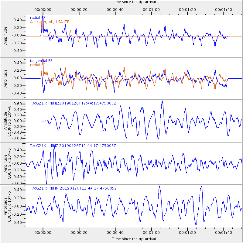
G21K Allakaket, AK, USA - Earthquake Result Viewer
*The percent match for this event was below the threshold and hence no stack was calculated.
| Earthquake location: |
Colombia |
| Earthquake latitude/longitude: |
3.0/-75.8 |
| Earthquake time(UTC): |
2019/01/26 (026) 12:32:27 GMT |
| Earthquake Depth: |
10 km |
| Earthquake Magnitude: |
5.6 Mww |
| Earthquake Catalog/Contributor: |
NEIC PDE/us |
|
| Network: |
TA USArray Transportable Network (new EarthScope stations) |
| Station: |
G21K Allakaket, AK, USA |
| Lat/Lon: |
66.52 N/153.51 W |
| Elevation: |
446 m |
|
| Distance: |
82.4 deg |
| Az: |
336.728 deg |
| Baz: |
100.086 deg |
| Ray Param: |
$rayparam |
*The percent match for this event was below the threshold and hence was not used in the summary stack. |
|
| Radial Match: |
58.797962 % |
| Radial Bump: |
392 |
| Transverse Match: |
58.42719 % |
| Transverse Bump: |
400 |
| SOD ConfigId: |
13570011 |
| Insert Time: |
2019-05-02 09:56:48.372 +0000 |
| GWidth: |
2.5 |
| Max Bumps: |
400 |
| Tol: |
0.001 |
|
Signal To Noise
| Channel | StoN | STA | LTA |
| TA:G21K: :BHZ:20190126T12:44:17.475005Z | 1.9501489 | 2.684476E-7 | 1.3765491E-7 |
| TA:G21K: :BHN:20190126T12:44:17.475005Z | 0.6907634 | 1.0593332E-7 | 1.5335688E-7 |
| TA:G21K: :BHE:20190126T12:44:17.475005Z | 1.0409396 | 2.035558E-7 | 1.9555007E-7 |
| Arrivals |
| Ps | |
| PpPs | |
| PsPs/PpSs | |


