You are here: Home > Network List > TA - USArray Transportable Network (new EarthScope stations) Stations List
> Station SFIN Lafayette, IN, USA > Earthquake Result Viewer
SFIN Lafayette, IN, USA - Earthquake Result Viewer

| Earthquake location: |
Baffin Bay |
| Earthquake latitude/longitude: |
75.4/-72.5 |
| Earthquake time(UTC): |
2009/07/07 (188) 19:11:46 GMT |
| Earthquake Depth: |
19 km |
| Earthquake Magnitude: |
5.9 MB, 5.7 MS, 6.1 MW, 6.0 MW |
| Earthquake Catalog/Contributor: |
WHDF/NEIC |
|
| Network: |
TA USArray Transportable Network (new EarthScope stations) |
| Station: |
SFIN Lafayette, IN, USA |
| Lat/Lon: |
40.38 N/87.10 W |
| Elevation: |
165 m |
|
| Distance: |
35.7 deg |
| Az: |
199.33 deg |
| Baz: |
6.331 deg |
| Ray Param: |
0.07706447 |
| Estimated Moho Depth: |
54.25 km |
| Estimated Crust Vp/Vs: |
1.66 |
| Assumed Crust Vp: |
6.498 km/s |
| Estimated Crust Vs: |
3.914 km/s |
| Estimated Crust Poisson's Ratio: |
0.22 |
|
| Radial Match: |
90.48493 % |
| Radial Bump: |
309 |
| Transverse Match: |
73.80545 % |
| Transverse Bump: |
395 |
| SOD ConfigId: |
2648 |
| Insert Time: |
2010-03-06 19:43:29.219 +0000 |
| GWidth: |
2.5 |
| Max Bumps: |
400 |
| Tol: |
0.001 |
|
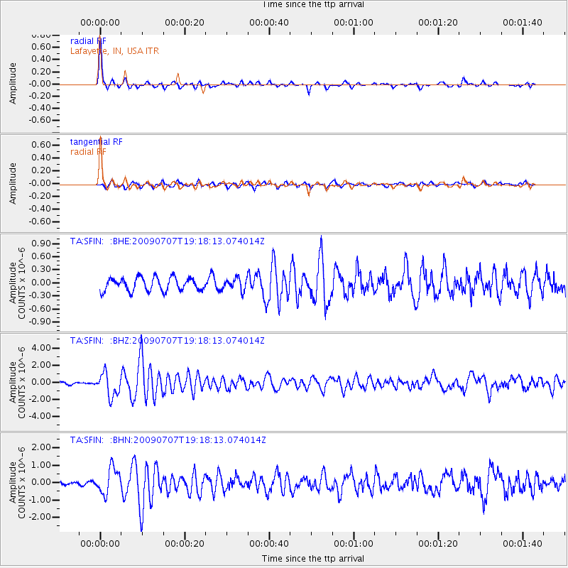
Signal To Noise
| Channel | StoN | STA | LTA |
| TA:SFIN: :BHZ:20090707T19:18:13.074014Z | 8.593246 | 1.3826311E-6 | 1.608974E-7 |
| TA:SFIN: :BHN:20090707T19:18:13.074014Z | 7.4370527 | 7.6187956E-7 | 1.0244376E-7 |
| TA:SFIN: :BHE:20090707T19:18:13.074014Z | 0.9261866 | 1.3886385E-7 | 1.4993074E-7 |
| Arrivals |
| Ps | 6.0 SECOND |
| PpPs | 20 SECOND |
| PsPs/PpSs | 26 SECOND |


