You are here: Home > Network List > TS - TERRAscope (Southern California Seismic Network) Stations List
> Station CALB Calabasas, California, USA > Earthquake Result Viewer
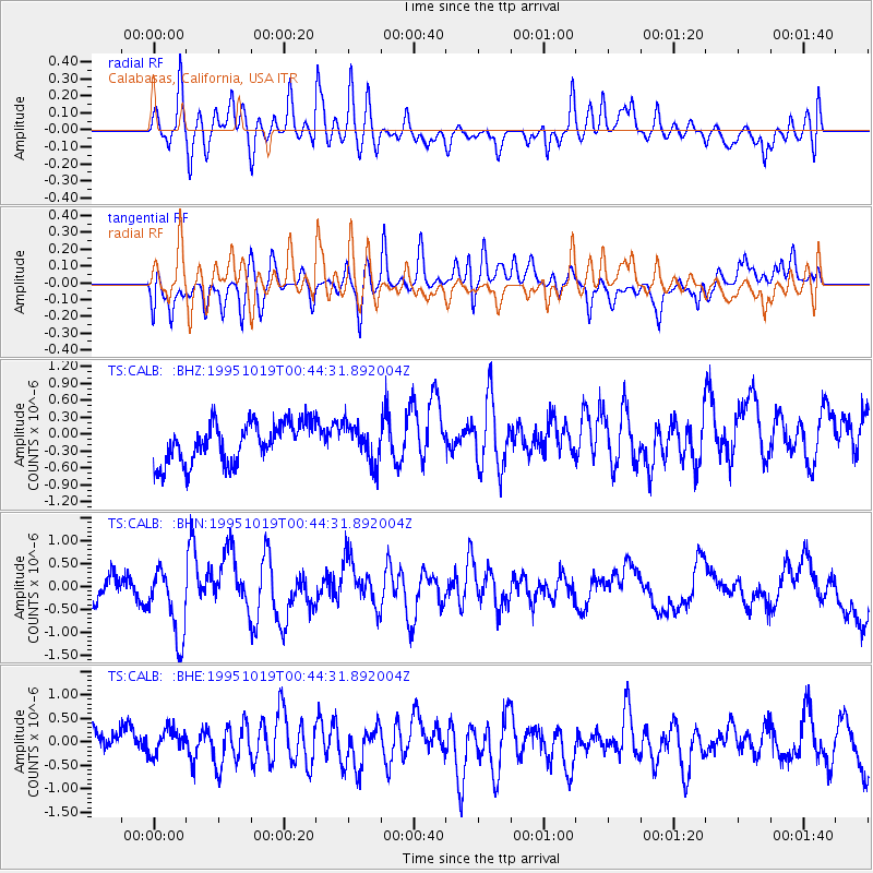
CALB Calabasas, California, USA - Earthquake Result Viewer
*The percent match for this event was below the threshold and hence no stack was calculated.
| Earthquake location: |
Ryukyu Islands, Japan |
| Earthquake latitude/longitude: |
28.1/130.2 |
| Earthquake time(UTC): |
1995/10/19 (292) 00:32:06 GMT |
| Earthquake Depth: |
33 km |
| Earthquake Magnitude: |
5.9 MB, 6.3 MS, 6.1 UNKNOWN, 6.4 MW |
| Earthquake Catalog/Contributor: |
WHDF/NEIC |
|
| Network: |
TS TERRAscope (Southern California Seismic Network) |
| Station: |
CALB Calabasas, California, USA |
| Lat/Lon: |
34.14 N/118.63 W |
| Elevation: |
0.0 m |
|
| Distance: |
90.1 deg |
| Az: |
50.663 deg |
| Baz: |
304.564 deg |
| Ray Param: |
$rayparam |
*The percent match for this event was below the threshold and hence was not used in the summary stack. |
|
| Radial Match: |
62.072884 % |
| Radial Bump: |
400 |
| Transverse Match: |
68.48284 % |
| Transverse Bump: |
400 |
| SOD ConfigId: |
4480 |
| Insert Time: |
2010-02-26 14:04:31.968 +0000 |
| GWidth: |
2.5 |
| Max Bumps: |
400 |
| Tol: |
0.001 |
|
Signal To Noise
| Channel | StoN | STA | LTA |
| TS:CALB: :BHN:19951019T00:44:31.892004Z | 2.4261436 | 7.6350557E-7 | 3.1469924E-7 |
| TS:CALB: :BHE:19951019T00:44:31.892004Z | 1.092723 | 2.71284E-7 | 2.482642E-7 |
| TS:CALB: :BHZ:19951019T00:44:31.892004Z | 0.9463765 | 3.3308987E-7 | 3.519634E-7 |
| Arrivals |
| Ps | |
| PpPs | |
| PsPs/PpSs | |


