You are here: Home > Network List > TA - USArray Transportable Network (new EarthScope stations) Stations List
> Station SFIN Lafayette, IN, USA > Earthquake Result Viewer
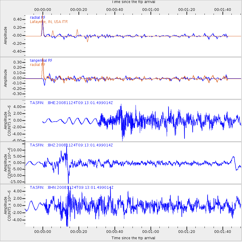
SFIN Lafayette, IN, USA - Earthquake Result Viewer
*The percent match for this event was below the threshold and hence no stack was calculated.
| Earthquake location: |
Sea Of Okhotsk |
| Earthquake latitude/longitude: |
54.2/154.3 |
| Earthquake time(UTC): |
2008/11/24 (329) 09:02:58 GMT |
| Earthquake Depth: |
492 km |
| Earthquake Magnitude: |
6.5 MB, 7.3 MW, 7.3 MW |
| Earthquake Catalog/Contributor: |
WHDF/NEIC |
|
| Network: |
TA USArray Transportable Network (new EarthScope stations) |
| Station: |
SFIN Lafayette, IN, USA |
| Lat/Lon: |
40.38 N/87.10 W |
| Elevation: |
165 m |
|
| Distance: |
72.1 deg |
| Az: |
44.828 deg |
| Baz: |
327.168 deg |
| Ray Param: |
$rayparam |
*The percent match for this event was below the threshold and hence was not used in the summary stack. |
|
| Radial Match: |
66.63111 % |
| Radial Bump: |
339 |
| Transverse Match: |
47.550194 % |
| Transverse Bump: |
400 |
| SOD ConfigId: |
2658 |
| Insert Time: |
2010-03-06 19:43:55.315 +0000 |
| GWidth: |
2.5 |
| Max Bumps: |
400 |
| Tol: |
0.001 |
|
Signal To Noise
| Channel | StoN | STA | LTA |
| TA:SFIN: :BHZ:20081124T09:13:01.499014Z | 2.5035727 | 1.6703682E-6 | 6.6719383E-7 |
| TA:SFIN: :BHN:20081124T09:13:01.499014Z | 1.4898123 | 9.3514313E-7 | 6.276919E-7 |
| TA:SFIN: :BHE:20081124T09:13:01.499014Z | 1.7413601 | 9.040297E-7 | 5.191515E-7 |
| Arrivals |
| Ps | |
| PpPs | |
| PsPs/PpSs | |


