You are here: Home > Network List > AV - Alaska Volcano Observatory Stations List
> Station SPCR Ckakachatna River, Mount Spurr, Alaska > Earthquake Result Viewer
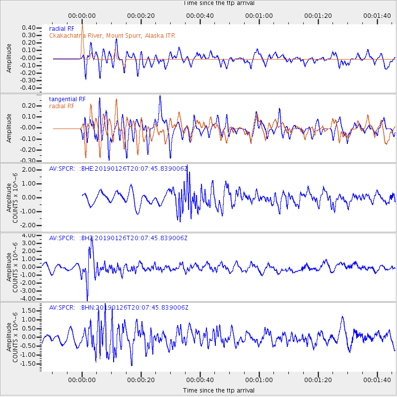
SPCR Ckakachatna River, Mount Spurr, Alaska - Earthquake Result Viewer
*The percent match for this event was below the threshold and hence no stack was calculated.
| Earthquake location: |
Fiji Islands Region |
| Earthquake latitude/longitude: |
-21.1/-178.9 |
| Earthquake time(UTC): |
2019/01/26 (026) 19:56:42 GMT |
| Earthquake Depth: |
579 km |
| Earthquake Magnitude: |
6.2 Mww |
| Earthquake Catalog/Contributor: |
NEIC PDE/us |
|
| Network: |
AV Alaska Volcano Observatory |
| Station: |
SPCR Ckakachatna River, Mount Spurr, Alaska |
| Lat/Lon: |
61.20 N/152.21 W |
| Elevation: |
984 m |
|
| Distance: |
84.8 deg |
| Az: |
12.598 deg |
| Baz: |
204.865 deg |
| Ray Param: |
$rayparam |
*The percent match for this event was below the threshold and hence was not used in the summary stack. |
|
| Radial Match: |
60.85657 % |
| Radial Bump: |
400 |
| Transverse Match: |
58.65553 % |
| Transverse Bump: |
400 |
| SOD ConfigId: |
13570011 |
| Insert Time: |
2019-05-02 10:00:40.293 +0000 |
| GWidth: |
2.5 |
| Max Bumps: |
400 |
| Tol: |
0.001 |
|
Signal To Noise
| Channel | StoN | STA | LTA |
| AV:SPCR: :BHZ:20190126T20:07:45.839006Z | 5.0838575 | 1.8824569E-6 | 3.7028119E-7 |
| AV:SPCR: :BHN:20190126T20:07:45.839006Z | 1.6872633 | 5.258341E-7 | 3.116491E-7 |
| AV:SPCR: :BHE:20190126T20:07:45.839006Z | 1.7666057 | 7.6783147E-7 | 4.3463658E-7 |
| Arrivals |
| Ps | |
| PpPs | |
| PsPs/PpSs | |


