You are here: Home > Network List > TA - USArray Transportable Network (new EarthScope stations) Stations List
> Station SFIN Lafayette, IN, USA > Earthquake Result Viewer
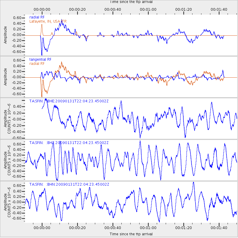
SFIN Lafayette, IN, USA - Earthquake Result Viewer
*The percent match for this event was below the threshold and hence no stack was calculated.
| Earthquake location: |
Near East Coast Of Honshu, Japan |
| Earthquake latitude/longitude: |
36.7/141.1 |
| Earthquake time(UTC): |
2009/01/31 (031) 21:51:52 GMT |
| Earthquake Depth: |
34 km |
| Earthquake Magnitude: |
5.6 MB, 5.3 MS, 5.8 MW, 5.7 MW |
| Earthquake Catalog/Contributor: |
WHDF/NEIC |
|
| Network: |
TA USArray Transportable Network (new EarthScope stations) |
| Station: |
SFIN Lafayette, IN, USA |
| Lat/Lon: |
40.38 N/87.10 W |
| Elevation: |
165 m |
|
| Distance: |
91.4 deg |
| Az: |
34.754 deg |
| Baz: |
323.16 deg |
| Ray Param: |
$rayparam |
*The percent match for this event was below the threshold and hence was not used in the summary stack. |
|
| Radial Match: |
40.948032 % |
| Radial Bump: |
400 |
| Transverse Match: |
63.95872 % |
| Transverse Bump: |
400 |
| SOD ConfigId: |
2658 |
| Insert Time: |
2010-03-06 19:44:25.231 +0000 |
| GWidth: |
2.5 |
| Max Bumps: |
400 |
| Tol: |
0.001 |
|
Signal To Noise
| Channel | StoN | STA | LTA |
| TA:SFIN: :BHZ:20090131T22:04:23.45002Z | 0.87474775 | 2.5519049E-7 | 2.9173037E-7 |
| TA:SFIN: :BHN:20090131T22:04:23.45002Z | 1.1370237 | 3.5017007E-7 | 3.079708E-7 |
| TA:SFIN: :BHE:20090131T22:04:23.45002Z | 1.0410783 | 2.8252614E-7 | 2.7137838E-7 |
| Arrivals |
| Ps | |
| PpPs | |
| PsPs/PpSs | |


