You are here: Home > Network List > TA - USArray Transportable Network (new EarthScope stations) Stations List
> Station H24A Dirks Ranch, Alva, WY, USA > Earthquake Result Viewer
H24A Dirks Ranch, Alva, WY, USA - Earthquake Result Viewer
| Earthquake location: |
Andreanof Islands, Aleutian Is. |
| Earthquake latitude/longitude: |
51.6/-174.4 |
| Earthquake time(UTC): |
2008/11/02 (307) 13:48:42 GMT |
| Earthquake Depth: |
36 km |
| Earthquake Magnitude: |
5.7 MB, 5.8 MS, 6.1 MW, 6.1 MW |
| Earthquake Catalog/Contributor: |
WHDF/NEIC |
|
| Network: |
TA USArray Transportable Network (new EarthScope stations) |
| Station: |
H24A Dirks Ranch, Alva, WY, USA |
| Lat/Lon: |
44.75 N/104.55 W |
| Elevation: |
1166 m |
|
| Distance: |
45.4 deg |
| Az: |
69.808 deg |
| Baz: |
304.679 deg |
| Ray Param: |
0.07119374 |
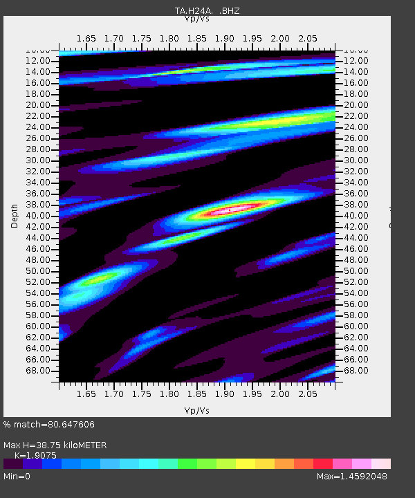
| Estimated Moho Depth: |
38.75 km |
| Estimated Crust Vp/Vs: |
1.91 |
| Assumed Crust Vp: |
6.242 km/s |
| Estimated Crust Vs: |
3.272 km/s |
| Estimated Crust Poisson's Ratio: |
0.31 |
|
| Radial Match: |
80.647606 % |
| Radial Bump: |
400 |
| Transverse Match: |
55.921165 % |
| Transverse Bump: |
400 |
| SOD ConfigId: |
2658 |
| Insert Time: |
2010-03-06 19:44:37.395 +0000 |
| GWidth: |
2.5 |
| Max Bumps: |
400 |
| Tol: |
0.001 |
|
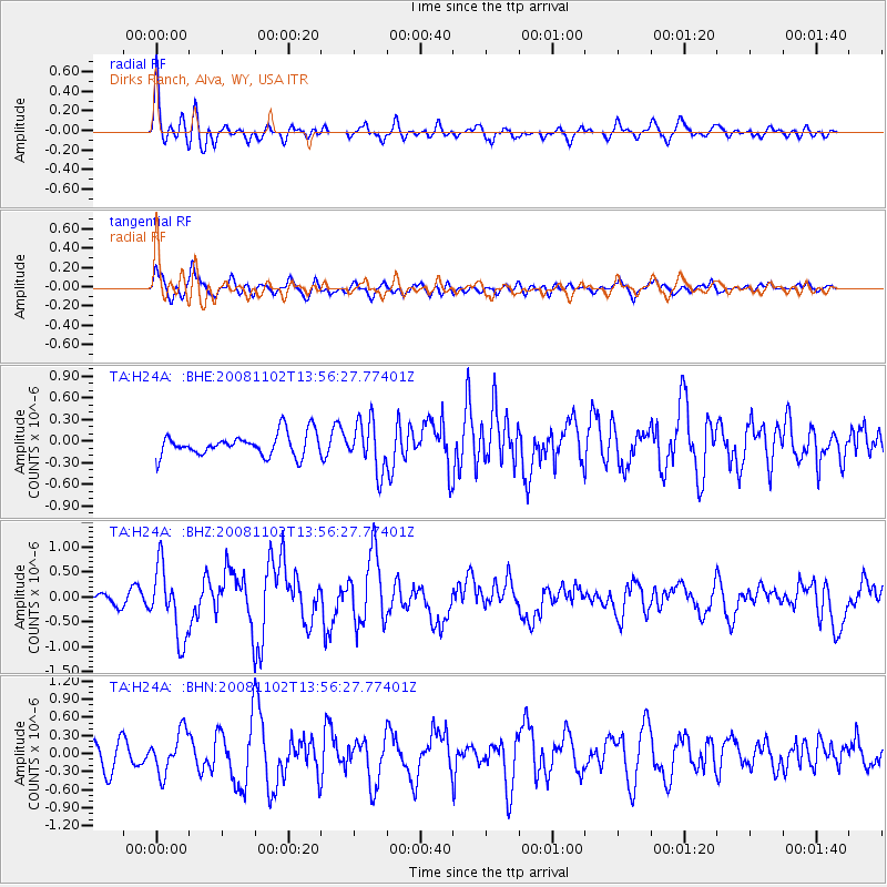
Signal To Noise
| Channel | StoN | STA | LTA |
| TA:H24A: :BHZ:20081102T13:56:27.77401Z | 8.563514 | 7.0452614E-7 | 8.227069E-8 |
| TA:H24A: :BHN:20081102T13:56:27.77401Z | 1.6140951 | 3.392663E-7 | 2.101898E-7 |
| TA:H24A: :BHE:20081102T13:56:27.77401Z | 2.1892018 | 3.393879E-7 | 1.5502815E-7 |
| Arrivals |
| Ps | 6.0 SECOND |
| PpPs | 17 SECOND |
| PsPs/PpSs | 23 SECOND |


