You are here: Home > Network List > TA - USArray Transportable Network (new EarthScope stations) Stations List
> Station H24A Dirks Ranch, Alva, WY, USA > Earthquake Result Viewer
H24A Dirks Ranch, Alva, WY, USA - Earthquake Result Viewer
| Earthquake location: |
East Of Kuril Islands |
| Earthquake latitude/longitude: |
46.9/155.2 |
| Earthquake time(UTC): |
2009/01/15 (015) 17:49:39 GMT |
| Earthquake Depth: |
36 km |
| Earthquake Magnitude: |
6.9 MB, 7.5 MS, 7.4 MW, 7.4 MW |
| Earthquake Catalog/Contributor: |
WHDF/NEIC |
|
| Network: |
TA USArray Transportable Network (new EarthScope stations) |
| Station: |
H24A Dirks Ranch, Alva, WY, USA |
| Lat/Lon: |
44.75 N/104.55 W |
| Elevation: |
1166 m |
|
| Distance: |
65.0 deg |
| Az: |
50.688 deg |
| Baz: |
311.829 deg |
| Ray Param: |
0.058510754 |
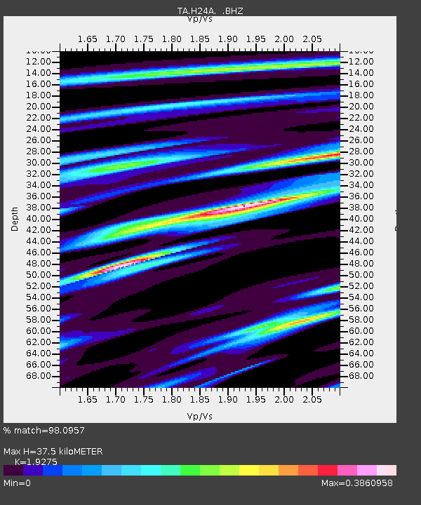
| Estimated Moho Depth: |
37.5 km |
| Estimated Crust Vp/Vs: |
1.93 |
| Assumed Crust Vp: |
6.242 km/s |
| Estimated Crust Vs: |
3.238 km/s |
| Estimated Crust Poisson's Ratio: |
0.32 |
|
| Radial Match: |
98.0957 % |
| Radial Bump: |
200 |
| Transverse Match: |
88.81432 % |
| Transverse Bump: |
400 |
| SOD ConfigId: |
2834 |
| Insert Time: |
2010-03-06 19:44:40.579 +0000 |
| GWidth: |
2.5 |
| Max Bumps: |
400 |
| Tol: |
0.001 |
|

Signal To Noise
| Channel | StoN | STA | LTA |
| TA:H24A: :BHZ:20090115T17:59:44.525017Z | 16.573275 | 1.15176135E-5 | 6.9495104E-7 |
| TA:H24A: :BHN:20090115T17:59:44.525017Z | 6.836274 | 4.3303526E-6 | 6.334375E-7 |
| TA:H24A: :BHE:20090115T17:59:44.525017Z | 5.686635 | 4.181957E-6 | 7.35401E-7 |
| Arrivals |
| Ps | 5.8 SECOND |
| PpPs | 17 SECOND |
| PsPs/PpSs | 23 SECOND |


