You are here: Home > Network List > TA - USArray Transportable Network (new EarthScope stations) Stations List
> Station H24A Dirks Ranch, Alva, WY, USA > Earthquake Result Viewer
H24A Dirks Ranch, Alva, WY, USA - Earthquake Result Viewer
| Earthquake location: |
Southeast Of Honshu, Japan |
| Earthquake latitude/longitude: |
32.8/140.4 |
| Earthquake time(UTC): |
2009/08/12 (224) 22:48:51 GMT |
| Earthquake Depth: |
53 km |
| Earthquake Magnitude: |
6.2 MB, 6.6 MW, 6.6 MW |
| Earthquake Catalog/Contributor: |
WHDF/NEIC |
|
| Network: |
TA USArray Transportable Network (new EarthScope stations) |
| Station: |
H24A Dirks Ranch, Alva, WY, USA |
| Lat/Lon: |
44.75 N/104.55 W |
| Elevation: |
1166 m |
|
| Distance: |
82.9 deg |
| Az: |
40.586 deg |
| Baz: |
309.756 deg |
| Ray Param: |
0.04650463 |
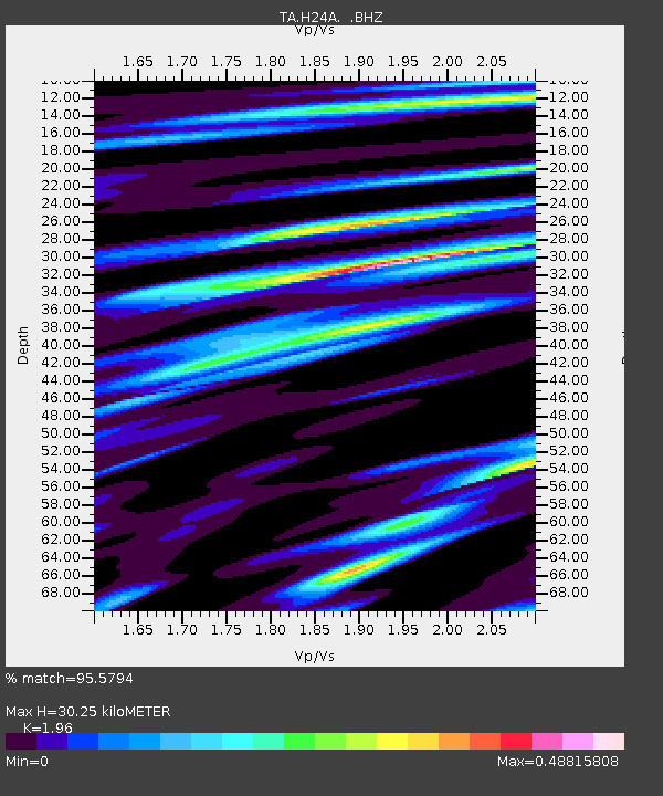
| Estimated Moho Depth: |
30.25 km |
| Estimated Crust Vp/Vs: |
1.96 |
| Assumed Crust Vp: |
6.242 km/s |
| Estimated Crust Vs: |
3.185 km/s |
| Estimated Crust Poisson's Ratio: |
0.32 |
|
| Radial Match: |
95.5794 % |
| Radial Bump: |
400 |
| Transverse Match: |
81.7202 % |
| Transverse Bump: |
400 |
| SOD ConfigId: |
2622 |
| Insert Time: |
2010-03-06 19:44:44.733 +0000 |
| GWidth: |
2.5 |
| Max Bumps: |
400 |
| Tol: |
0.001 |
|

Signal To Noise
| Channel | StoN | STA | LTA |
| TA:H24A: :BHZ:20090812T23:00:39.099016Z | 45.739597 | 2.4883705E-6 | 5.4402978E-8 |
| TA:H24A: :BHN:20090812T23:00:39.099016Z | 6.9623184 | 6.219542E-7 | 8.933148E-8 |
| TA:H24A: :BHE:20090812T23:00:39.099016Z | 18.2678 | 7.443803E-7 | 4.0748223E-8 |
| Arrivals |
| Ps | 4.8 SECOND |
| PpPs | 14 SECOND |
| PsPs/PpSs | 19 SECOND |


