You are here: Home > Network List > TA - USArray Transportable Network (new EarthScope stations) Stations List
> Station H24A Dirks Ranch, Alva, WY, USA > Earthquake Result Viewer
H24A Dirks Ranch, Alva, WY, USA - Earthquake Result Viewer
| Earthquake location: |
East Of Severnaya Zemlya |
| Earthquake latitude/longitude: |
81.6/119.5 |
| Earthquake time(UTC): |
2009/10/07 (280) 20:52:13 GMT |
| Earthquake Depth: |
8.0 km |
| Earthquake Magnitude: |
5.7 MB, 5.1 MS, 5.8 MW, 5.8 MW |
| Earthquake Catalog/Contributor: |
WHDF/NEIC |
|
| Network: |
TA USArray Transportable Network (new EarthScope stations) |
| Station: |
H24A Dirks Ranch, Alva, WY, USA |
| Lat/Lon: |
44.75 N/104.55 W |
| Elevation: |
1166 m |
|
| Distance: |
51.8 deg |
| Az: |
39.113 deg |
| Baz: |
352.495 deg |
| Ray Param: |
0.06718058 |
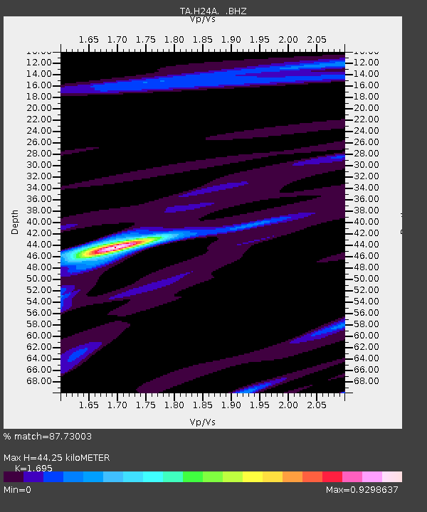
| Estimated Moho Depth: |
44.25 km |
| Estimated Crust Vp/Vs: |
1.70 |
| Assumed Crust Vp: |
6.242 km/s |
| Estimated Crust Vs: |
3.683 km/s |
| Estimated Crust Poisson's Ratio: |
0.23 |
|
| Radial Match: |
87.73003 % |
| Radial Bump: |
400 |
| Transverse Match: |
67.381996 % |
| Transverse Bump: |
400 |
| SOD ConfigId: |
2622 |
| Insert Time: |
2010-03-06 19:45:01.507 +0000 |
| GWidth: |
2.5 |
| Max Bumps: |
400 |
| Tol: |
0.001 |
|
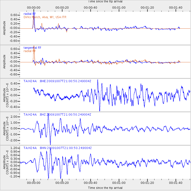
Signal To Noise
| Channel | StoN | STA | LTA |
| TA:H24A: :BHZ:20091007T21:00:50.249004Z | 10.71023 | 7.170549E-7 | 6.695047E-8 |
| TA:H24A: :BHN:20091007T21:00:50.249004Z | 5.703638 | 4.3987345E-7 | 7.7121555E-8 |
| TA:H24A: :BHE:20091007T21:00:50.249004Z | 0.61816984 | 6.5610266E-8 | 1.0613631E-7 |
| Arrivals |
| Ps | 5.2 SECOND |
| PpPs | 18 SECOND |
| PsPs/PpSs | 23 SECOND |


