You are here: Home > Network List > TA - USArray Transportable Network (new EarthScope stations) Stations List
> Station H24A Dirks Ranch, Alva, WY, USA > Earthquake Result Viewer
H24A Dirks Ranch, Alva, WY, USA - Earthquake Result Viewer
| Earthquake location: |
Ryukyu Islands, Japan |
| Earthquake latitude/longitude: |
29.2/129.8 |
| Earthquake time(UTC): |
2009/10/30 (303) 07:03:39 GMT |
| Earthquake Depth: |
34 km |
| Earthquake Magnitude: |
6.3 MB, 6.8 MS, 6.8 MW, 6.8 MW |
| Earthquake Catalog/Contributor: |
WHDF/NEIC |
|
| Network: |
TA USArray Transportable Network (new EarthScope stations) |
| Station: |
H24A Dirks Ranch, Alva, WY, USA |
| Lat/Lon: |
44.75 N/104.55 W |
| Elevation: |
1166 m |
|
| Distance: |
91.3 deg |
| Az: |
35.385 deg |
| Baz: |
314.734 deg |
| Ray Param: |
0.041608643 |
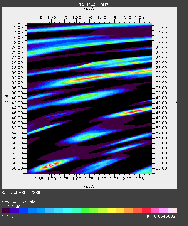
| Estimated Moho Depth: |
66.75 km |
| Estimated Crust Vp/Vs: |
1.69 |
| Assumed Crust Vp: |
6.242 km/s |
| Estimated Crust Vs: |
3.693 km/s |
| Estimated Crust Poisson's Ratio: |
0.23 |
|
| Radial Match: |
89.72339 % |
| Radial Bump: |
353 |
| Transverse Match: |
68.46499 % |
| Transverse Bump: |
400 |
| SOD ConfigId: |
2622 |
| Insert Time: |
2010-03-06 19:45:06.781 +0000 |
| GWidth: |
2.5 |
| Max Bumps: |
400 |
| Tol: |
0.001 |
|

Signal To Noise
| Channel | StoN | STA | LTA |
| TA:H24A: :BHZ:20091030T07:16:09.825017Z | 7.433784 | 1.7895969E-6 | 2.4073836E-7 |
| TA:H24A: :BHN:20091030T07:16:09.825017Z | 3.0328012 | 5.6438097E-7 | 1.8609231E-7 |
| TA:H24A: :BHE:20091030T07:16:09.825017Z | 2.2460938 | 4.1590815E-7 | 1.8516954E-7 |
| Arrivals |
| Ps | 7.5 SECOND |
| PpPs | 28 SECOND |
| PsPs/PpSs | 36 SECOND |


