You are here: Home > Network List > TA - USArray Transportable Network (new EarthScope stations) Stations List
> Station H16K Elim, AK, USA > Earthquake Result Viewer
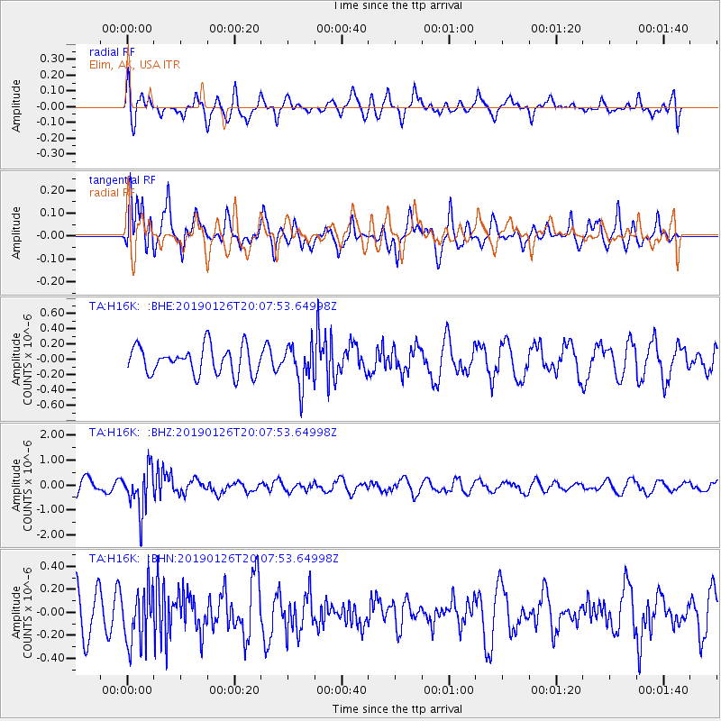
H16K Elim, AK, USA - Earthquake Result Viewer
*The percent match for this event was below the threshold and hence no stack was calculated.
| Earthquake location: |
Fiji Islands Region |
| Earthquake latitude/longitude: |
-21.1/-178.9 |
| Earthquake time(UTC): |
2019/01/26 (026) 19:56:42 GMT |
| Earthquake Depth: |
579 km |
| Earthquake Magnitude: |
6.2 Mww |
| Earthquake Catalog/Contributor: |
NEIC PDE/us |
|
| Network: |
TA USArray Transportable Network (new EarthScope stations) |
| Station: |
H16K Elim, AK, USA |
| Lat/Lon: |
64.64 N/162.24 W |
| Elevation: |
216 m |
|
| Distance: |
86.5 deg |
| Az: |
7.091 deg |
| Baz: |
195.519 deg |
| Ray Param: |
$rayparam |
*The percent match for this event was below the threshold and hence was not used in the summary stack. |
|
| Radial Match: |
63.1424 % |
| Radial Bump: |
400 |
| Transverse Match: |
56.589657 % |
| Transverse Bump: |
399 |
| SOD ConfigId: |
13570011 |
| Insert Time: |
2019-05-02 10:05:57.830 +0000 |
| GWidth: |
2.5 |
| Max Bumps: |
400 |
| Tol: |
0.001 |
|
Signal To Noise
| Channel | StoN | STA | LTA |
| TA:H16K: :BHZ:20190126T20:07:53.64998Z | 3.8565269 | 8.612586E-7 | 2.2332493E-7 |
| TA:H16K: :BHN:20190126T20:07:53.64998Z | 1.4086896 | 2.4162125E-7 | 1.7152199E-7 |
| TA:H16K: :BHE:20190126T20:07:53.64998Z | 1.4602584 | 2.5796277E-7 | 1.7665558E-7 |
| Arrivals |
| Ps | |
| PpPs | |
| PsPs/PpSs | |


