You are here: Home > Network List > TA - USArray Transportable Network (new EarthScope stations) Stations List
> Station K24A Anderson Ranch, Keeline, WY, USA > Earthquake Result Viewer
K24A Anderson Ranch, Keeline, WY, USA - Earthquake Result Viewer
| Earthquake location: |
East Of Kuril Islands |
| Earthquake latitude/longitude: |
46.9/155.2 |
| Earthquake time(UTC): |
2009/01/15 (015) 17:49:39 GMT |
| Earthquake Depth: |
36 km |
| Earthquake Magnitude: |
6.9 MB, 7.5 MS, 7.4 MW, 7.4 MW |
| Earthquake Catalog/Contributor: |
WHDF/NEIC |
|
| Network: |
TA USArray Transportable Network (new EarthScope stations) |
| Station: |
K24A Anderson Ranch, Keeline, WY, USA |
| Lat/Lon: |
42.72 N/104.82 W |
| Elevation: |
1593 m |
|
| Distance: |
66.2 deg |
| Az: |
52.478 deg |
| Baz: |
312.388 deg |
| Ray Param: |
0.057713967 |
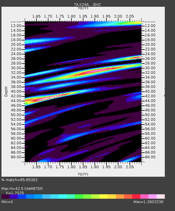
| Estimated Moho Depth: |
42.5 km |
| Estimated Crust Vp/Vs: |
1.70 |
| Assumed Crust Vp: |
6.159 km/s |
| Estimated Crust Vs: |
3.617 km/s |
| Estimated Crust Poisson's Ratio: |
0.24 |
|
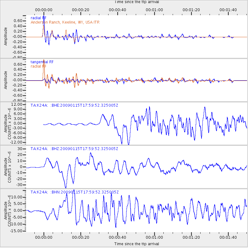
| Radial Match: |
95.95382 % |
| Radial Bump: |
400 |
| Transverse Match: |
86.0867 % |
| Transverse Bump: |
400 |
| SOD ConfigId: |
2834 |
| Insert Time: |
2010-03-06 19:47:12.329 +0000 |
| GWidth: |
2.5 |
| Max Bumps: |
400 |
| Tol: |
0.001 |
|
Signal To Noise
| Channel | StoN | STA | LTA |
| TA:K24A: :BHZ:20090115T17:59:52.325005Z | 18.162846 | 9.012349E-6 | 4.96197E-7 |
| TA:K24A: :BHN:20090115T17:59:52.325005Z | 4.8458233 | 3.1781008E-6 | 6.558433E-7 |
| TA:K24A: :BHE:20090115T17:59:52.325005Z | 9.174575 | 3.428408E-6 | 3.7368576E-7 |
| Arrivals |
| Ps | 5.0 SECOND |
| PpPs | 18 SECOND |
| PsPs/PpSs | 23 SECOND |


