You are here: Home > Network List > TA - USArray Transportable Network (new EarthScope stations) Stations List
> Station K24A Anderson Ranch, Keeline, WY, USA > Earthquake Result Viewer
K24A Anderson Ranch, Keeline, WY, USA - Earthquake Result Viewer
| Earthquake location: |
Near S. Coast Of Honshu, Japan |
| Earthquake latitude/longitude: |
33.2/137.9 |
| Earthquake time(UTC): |
2009/08/09 (221) 10:55:55 GMT |
| Earthquake Depth: |
297 km |
| Earthquake Magnitude: |
6.5 MB, 7.1 MW, 7.1 MW |
| Earthquake Catalog/Contributor: |
WHDF/NEIC |
|
| Network: |
TA USArray Transportable Network (new EarthScope stations) |
| Station: |
K24A Anderson Ranch, Keeline, WY, USA |
| Lat/Lon: |
42.72 N/104.82 W |
| Elevation: |
1593 m |
|
| Distance: |
85.1 deg |
| Az: |
41.114 deg |
| Baz: |
311.546 deg |
| Ray Param: |
0.044250853 |
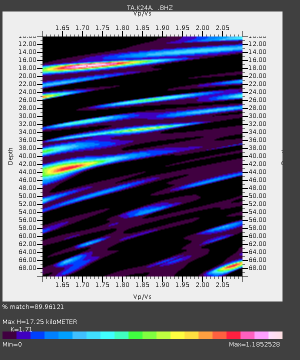
| Estimated Moho Depth: |
17.25 km |
| Estimated Crust Vp/Vs: |
1.71 |
| Assumed Crust Vp: |
6.159 km/s |
| Estimated Crust Vs: |
3.602 km/s |
| Estimated Crust Poisson's Ratio: |
0.24 |
|
| Radial Match: |
89.96121 % |
| Radial Bump: |
400 |
| Transverse Match: |
75.43091 % |
| Transverse Bump: |
400 |
| SOD ConfigId: |
2622 |
| Insert Time: |
2010-03-06 19:47:16.305 +0000 |
| GWidth: |
2.5 |
| Max Bumps: |
400 |
| Tol: |
0.001 |
|

Signal To Noise
| Channel | StoN | STA | LTA |
| TA:K24A: :BHZ:20090809T11:07:27.250015Z | 62.43738 | 6.0764637E-6 | 9.732092E-8 |
| TA:K24A: :BHN:20090809T11:07:27.250015Z | 32.594086 | 2.5401803E-6 | 7.7933784E-8 |
| TA:K24A: :BHE:20090809T11:07:27.250015Z | 26.466387 | 2.4385365E-6 | 9.2137114E-8 |
| Arrivals |
| Ps | 2.0 SECOND |
| PpPs | 7.4 SECOND |
| PsPs/PpSs | 9.5 SECOND |


