You are here: Home > Network List > TA - USArray Transportable Network (new EarthScope stations) Stations List
> Station K24A Anderson Ranch, Keeline, WY, USA > Earthquake Result Viewer
K24A Anderson Ranch, Keeline, WY, USA - Earthquake Result Viewer
| Earthquake location: |
Kuril Islands |
| Earthquake latitude/longitude: |
48.3/154.2 |
| Earthquake time(UTC): |
2009/09/10 (253) 02:46:50 GMT |
| Earthquake Depth: |
36 km |
| Earthquake Magnitude: |
6.0 MB, 5.5 MS, 6.0 MW, 5.8 MW |
| Earthquake Catalog/Contributor: |
WHDF/NEIC |
|
| Network: |
TA USArray Transportable Network (new EarthScope stations) |
| Station: |
K24A Anderson Ranch, Keeline, WY, USA |
| Lat/Lon: |
42.72 N/104.82 W |
| Elevation: |
1593 m |
|
| Distance: |
65.8 deg |
| Az: |
52.462 deg |
| Baz: |
314.09 deg |
| Ray Param: |
0.05795807 |
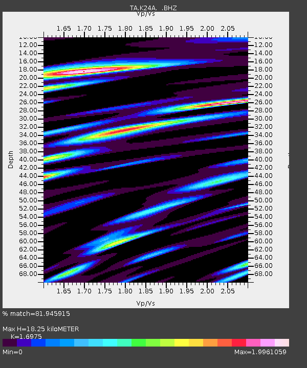
| Estimated Moho Depth: |
18.25 km |
| Estimated Crust Vp/Vs: |
1.70 |
| Assumed Crust Vp: |
6.159 km/s |
| Estimated Crust Vs: |
3.628 km/s |
| Estimated Crust Poisson's Ratio: |
0.23 |
|
| Radial Match: |
81.945915 % |
| Radial Bump: |
400 |
| Transverse Match: |
79.51544 % |
| Transverse Bump: |
400 |
| SOD ConfigId: |
2622 |
| Insert Time: |
2010-03-06 19:47:19.752 +0000 |
| GWidth: |
2.5 |
| Max Bumps: |
400 |
| Tol: |
0.001 |
|

Signal To Noise
| Channel | StoN | STA | LTA |
| TA:K24A: :BHZ:20090910T02:57:01.225Z | 4.089958 | 4.2617964E-7 | 1.0420147E-7 |
| TA:K24A: :BHN:20090910T02:57:01.225Z | 2.4185643 | 3.502716E-7 | 1.4482625E-7 |
| TA:K24A: :BHE:20090910T02:57:01.225Z | 2.172961 | 2.98235E-7 | 1.3724821E-7 |
| Arrivals |
| Ps | 2.1 SECOND |
| PpPs | 7.7 SECOND |
| PsPs/PpSs | 9.8 SECOND |


