You are here: Home > Network List > TA - USArray Transportable Network (new EarthScope stations) Stations List
> Station K24A Anderson Ranch, Keeline, WY, USA > Earthquake Result Viewer
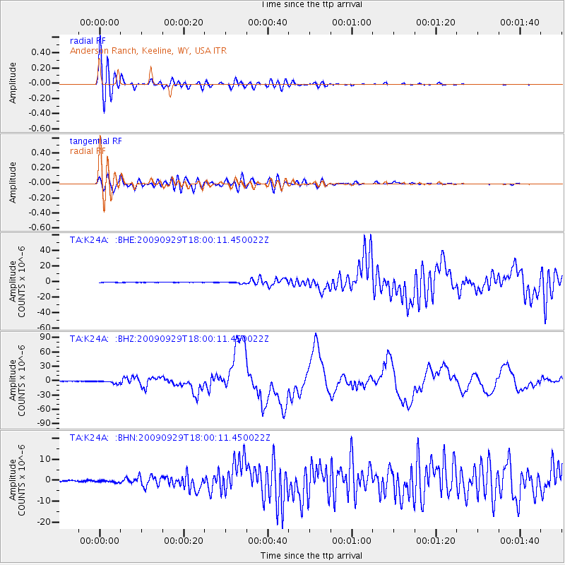
K24A Anderson Ranch, Keeline, WY, USA - Earthquake Result Viewer
| Earthquake location: |
Samoa Islands Region |
| Earthquake latitude/longitude: |
-15.5/-172.1 |
| Earthquake time(UTC): |
2009/09/29 (272) 17:48:10 GMT |
| Earthquake Depth: |
18 km |
| Earthquake Magnitude: |
7.1 MB, 8.1 MS, 8.1 MW, 8.0 MW |
| Earthquake Catalog/Contributor: |
WHDF/NEIC |
|
| Network: |
TA USArray Transportable Network (new EarthScope stations) |
| Station: |
K24A Anderson Ranch, Keeline, WY, USA |
| Lat/Lon: |
42.72 N/104.82 W |
| Elevation: |
1593 m |
|
| Distance: |
84.5 deg |
| Az: |
43.064 deg |
| Baz: |
243.299 deg |
| Ray Param: |
0.045389928 |
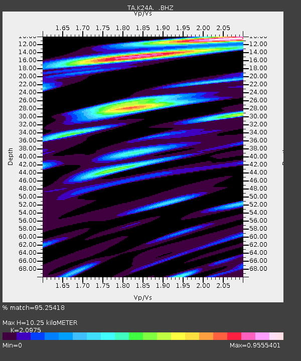
| Estimated Moho Depth: |
10.25 km |
| Estimated Crust Vp/Vs: |
2.10 |
| Assumed Crust Vp: |
6.159 km/s |
| Estimated Crust Vs: |
2.936 km/s |
| Estimated Crust Poisson's Ratio: |
0.35 |
|
| Radial Match: |
95.25418 % |
| Radial Bump: |
400 |
| Transverse Match: |
81.568115 % |
| Transverse Bump: |
400 |
| SOD ConfigId: |
2622 |
| Insert Time: |
2010-03-06 19:47:24.328 +0000 |
| GWidth: |
2.5 |
| Max Bumps: |
400 |
| Tol: |
0.001 |
|
Signal To Noise
| Channel | StoN | STA | LTA |
| TA:K24A: :BHZ:20090929T18:00:11.450022Z | 16.706926 | 3.269346E-6 | 1.9568807E-7 |
| TA:K24A: :BHN:20090929T18:00:11.450022Z | 2.5132184 | 5.1089165E-7 | 2.0328184E-7 |
| TA:K24A: :BHE:20090929T18:00:11.450022Z | 6.0506577 | 1.1038212E-6 | 1.8242996E-7 |
| Arrivals |
| Ps | 1.9 SECOND |
| PpPs | 5.1 SECOND |
| PsPs/PpSs | 6.9 SECOND |


