You are here: Home > Network List > CI - Caltech Regional Seismic Network Stations List
> Station MPM Manuel Prospect Mine, California, USA > Earthquake Result Viewer
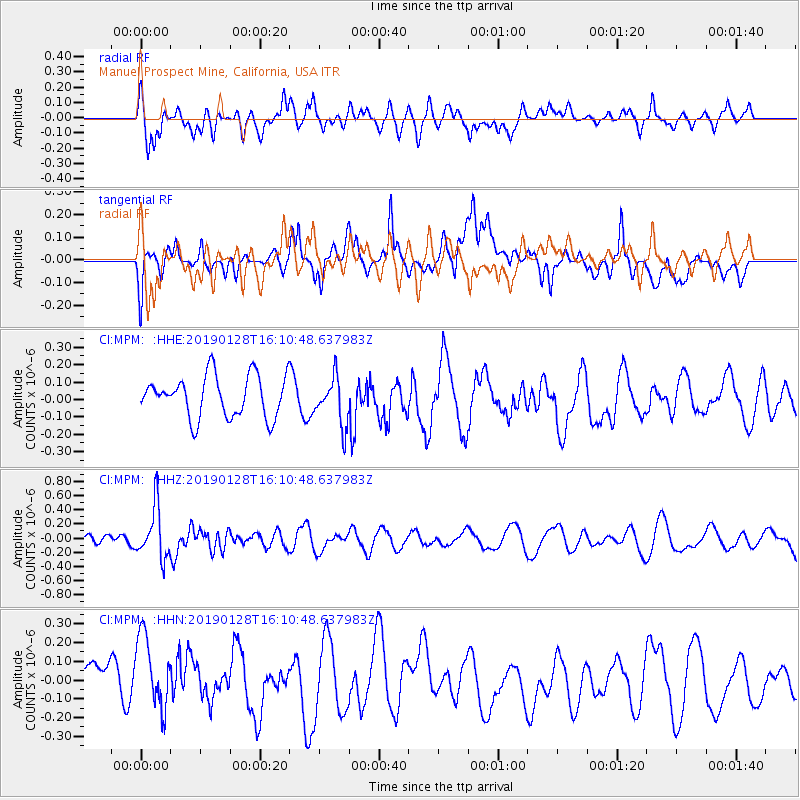
MPM Manuel Prospect Mine, California, USA - Earthquake Result Viewer
*The percent match for this event was below the threshold and hence no stack was calculated.
| Earthquake location: |
Fiji Islands Region |
| Earthquake latitude/longitude: |
-18.0/-179.3 |
| Earthquake time(UTC): |
2019/01/28 (028) 16:00:16 GMT |
| Earthquake Depth: |
621 km |
| Earthquake Magnitude: |
5.5 Mww |
| Earthquake Catalog/Contributor: |
NEIC PDE/us |
|
| Network: |
CI Caltech Regional Seismic Network |
| Station: |
MPM Manuel Prospect Mine, California, USA |
| Lat/Lon: |
36.06 N/117.49 W |
| Elevation: |
185 m |
|
| Distance: |
79.3 deg |
| Az: |
46.589 deg |
| Baz: |
238.565 deg |
| Ray Param: |
$rayparam |
*The percent match for this event was below the threshold and hence was not used in the summary stack. |
|
| Radial Match: |
63.114624 % |
| Radial Bump: |
400 |
| Transverse Match: |
47.97672 % |
| Transverse Bump: |
400 |
| SOD ConfigId: |
13570011 |
| Insert Time: |
2019-05-02 10:18:46.344 +0000 |
| GWidth: |
2.5 |
| Max Bumps: |
400 |
| Tol: |
0.001 |
|
Signal To Noise
| Channel | StoN | STA | LTA |
| CI:MPM: :HHZ:20190128T16:10:48.637983Z | 4.2073984 | 3.6122643E-7 | 8.585505E-8 |
| CI:MPM: :HHN:20190128T16:10:48.637983Z | 1.7733179 | 2.2347373E-7 | 1.2602011E-7 |
| CI:MPM: :HHE:20190128T16:10:48.637983Z | 1.1606848 | 1.3830541E-7 | 1.19158464E-7 |
| Arrivals |
| Ps | |
| PpPs | |
| PsPs/PpSs | |


