You are here: Home > Network List > TA - USArray Transportable Network (new EarthScope stations) Stations List
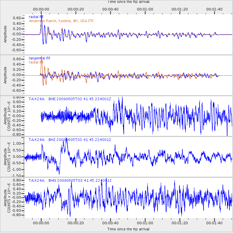
> Station K24A Anderson Ranch, Keeline, WY, USA > Earthquake Result Viewer
K24A Anderson Ranch, Keeline, WY, USA - Earthquake Result Viewer
| Earthquake location: |
Hokkaido, Japan Region |
| Earthquake latitude/longitude: |
41.8/143.4 |
| Earthquake time(UTC): |
2009/06/05 (156) 03:30:33 GMT |
| Earthquake Depth: |
29 km |
| Earthquake Magnitude: |
6.0 MB, 6.3 MS, 6.4 MW, 6.4 MW |
| Earthquake Catalog/Contributor: |
WHDF/NEIC |
|
| Network: |
TA USArray Transportable Network (new EarthScope stations) |
| Station: |
K24A Anderson Ranch, Keeline, WY, USA |
| Lat/Lon: |
42.72 N/104.82 W |
| Elevation: |
1593 m |
|
| Distance: |
75.8 deg |
| Az: |
44.913 deg |
| Baz: |
314.267 deg |
| Ray Param: |
0.051377118 |
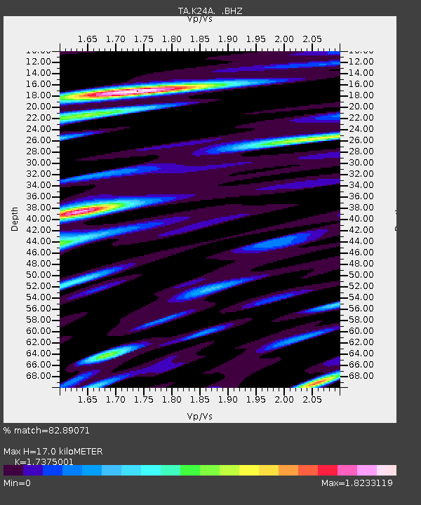
| Estimated Moho Depth: |
17.0 km |
| Estimated Crust Vp/Vs: |
1.74 |
| Assumed Crust Vp: |
6.159 km/s |
| Estimated Crust Vs: |
3.545 km/s |
| Estimated Crust Poisson's Ratio: |
0.25 |
|
| Radial Match: |
82.89071 % |
| Radial Bump: |
400 |
| Transverse Match: |
73.66334 % |
| Transverse Bump: |
400 |
| SOD ConfigId: |
2648 |
| Insert Time: |
2010-03-06 19:47:39.896 +0000 |
| GWidth: |
2.5 |
| Max Bumps: |
400 |
| Tol: |
0.001 |
|
Signal To Noise
| Channel | StoN | STA | LTA |
| TA:K24A: :BHZ:20090605T03:41:45.224001Z | 3.3385737 | 4.163408E-7 | 1.2470619E-7 |
| TA:K24A: :BHN:20090605T03:41:45.224001Z | 1.9931558 | 2.4786178E-7 | 1.2435643E-7 |
| TA:K24A: :BHE:20090605T03:41:45.224001Z | 1.8355334 | 2.1228621E-7 | 1.1565369E-7 |
| Arrivals |
| Ps | 2.1 SECOND |
| PpPs | 7.3 SECOND |
| PsPs/PpSs | 9.4 SECOND |


