You are here: Home > Network List > US - United States National Seismic Network Stations List
> Station OGNE Ogallala, Nebraska, USA > Earthquake Result Viewer
OGNE Ogallala, Nebraska, USA - Earthquake Result Viewer
| Earthquake location: |
Northern Peru |
| Earthquake latitude/longitude: |
-5.6/-77.0 |
| Earthquake time(UTC): |
2016/09/10 (254) 10:08:20 GMT |
| Earthquake Depth: |
114 km |
| Earthquake Magnitude: |
6.0 MB |
| Earthquake Catalog/Contributor: |
NEIC PDE/NEIC ALERT |
|
| Network: |
US United States National Seismic Network |
| Station: |
OGNE Ogallala, Nebraska, USA |
| Lat/Lon: |
40.95 N/102.03 W |
| Elevation: |
1054 m |
|
| Distance: |
51.7 deg |
| Az: |
335.857 deg |
| Baz: |
147.492 deg |
| Ray Param: |
0.06686891 |
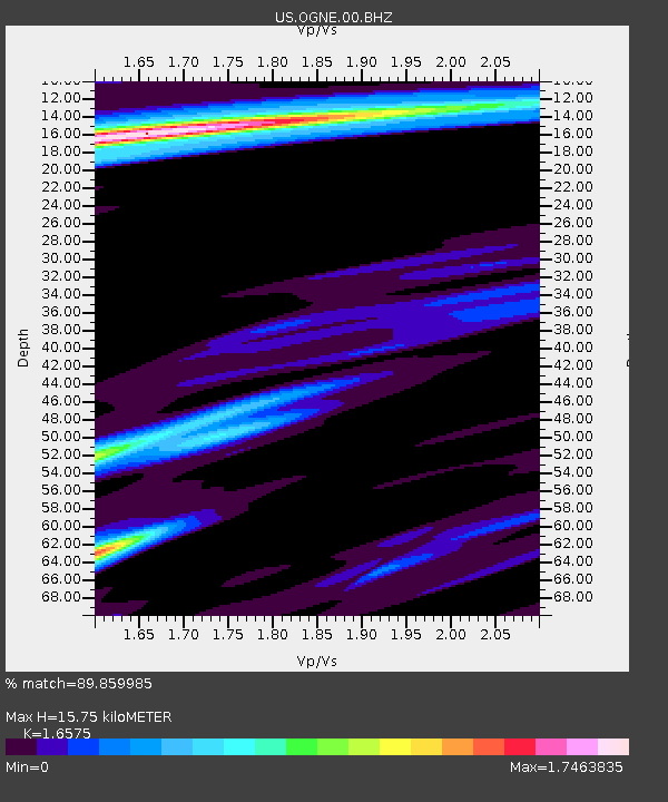
| Estimated Moho Depth: |
15.75 km |
| Estimated Crust Vp/Vs: |
1.66 |
| Assumed Crust Vp: |
6.483 km/s |
| Estimated Crust Vs: |
3.911 km/s |
| Estimated Crust Poisson's Ratio: |
0.21 |
|
| Radial Match: |
89.859985 % |
| Radial Bump: |
349 |
| Transverse Match: |
77.47702 % |
| Transverse Bump: |
371 |
| SOD ConfigId: |
1634031 |
| Insert Time: |
2016-09-24 10:17:44.617 +0000 |
| GWidth: |
2.5 |
| Max Bumps: |
400 |
| Tol: |
0.001 |
|
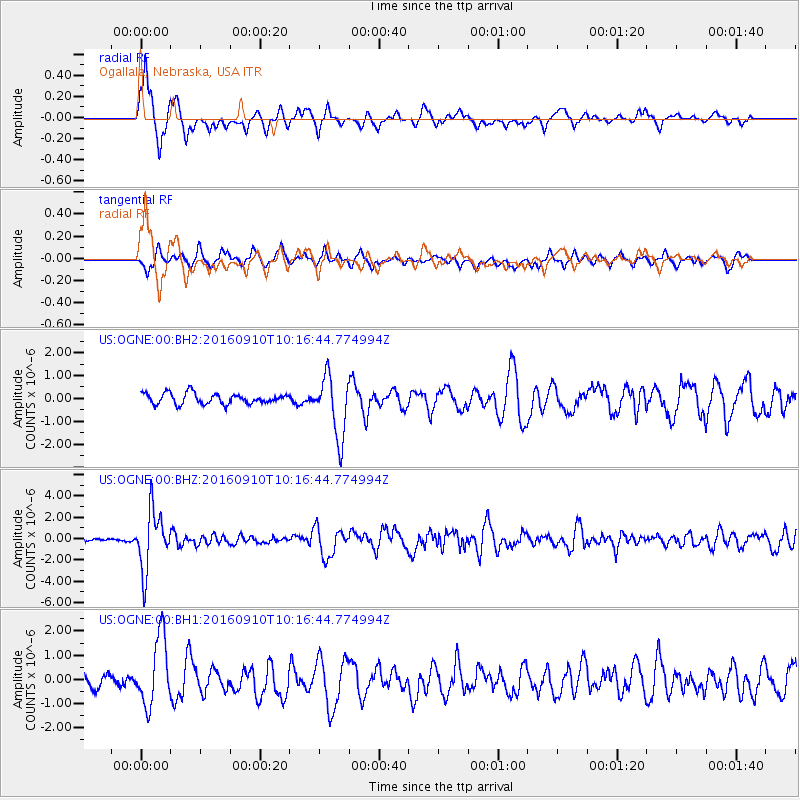
Signal To Noise
| Channel | StoN | STA | LTA |
| US:OGNE:00:BHZ:20160910T10:16:44.774994Z | 25.90054 | 2.7652268E-6 | 1.0676329E-7 |
| US:OGNE:00:BH1:20160910T10:16:44.774994Z | 5.8769593 | 1.4434935E-6 | 2.456191E-7 |
| US:OGNE:00:BH2:20160910T10:16:44.774994Z | 5.8104305 | 1.3386925E-6 | 2.3039473E-7 |
| Arrivals |
| Ps | 1.7 SECOND |
| PpPs | 6.1 SECOND |
| PsPs/PpSs | 7.8 SECOND |


