You are here: Home > Network List > TA - USArray Transportable Network (new EarthScope stations) Stations List
> Station E22A Miles City, MT, USA > Earthquake Result Viewer
E22A Miles City, MT, USA - Earthquake Result Viewer
| Earthquake location: |
Costa Rica |
| Earthquake latitude/longitude: |
10.2/-84.2 |
| Earthquake time(UTC): |
2009/01/08 (008) 19:21:35 GMT |
| Earthquake Depth: |
14 km |
| Earthquake Magnitude: |
5.7 MB, 6.0 MS, 6.1 MW, 6.1 MW |
| Earthquake Catalog/Contributor: |
WHDF/NEIC |
|
| Network: |
TA USArray Transportable Network (new EarthScope stations) |
| Station: |
E22A Miles City, MT, USA |
| Lat/Lon: |
46.44 N/105.95 W |
| Elevation: |
784 m |
|
| Distance: |
40.6 deg |
| Az: |
336.819 deg |
| Baz: |
145.918 deg |
| Ray Param: |
0.07428353 |
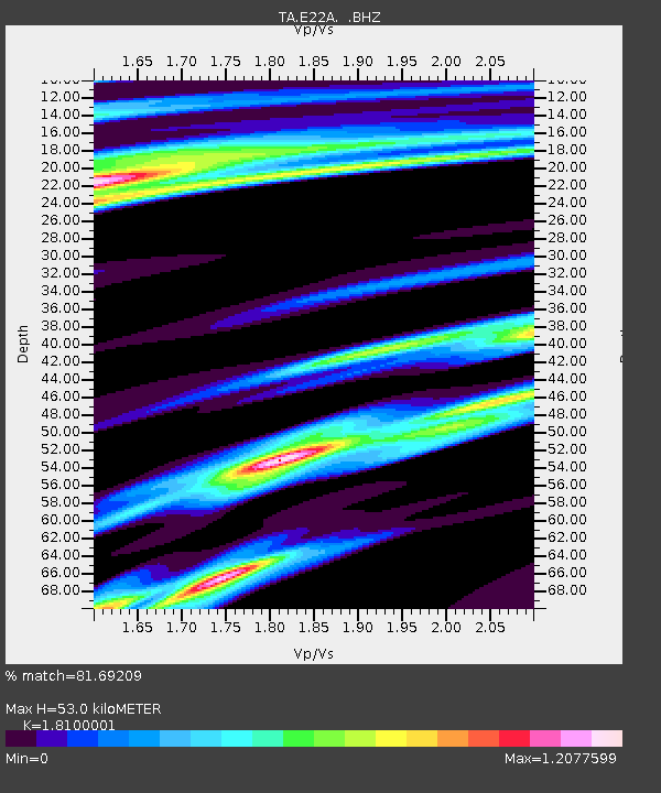
| Estimated Moho Depth: |
53.0 km |
| Estimated Crust Vp/Vs: |
1.81 |
| Assumed Crust Vp: |
6.438 km/s |
| Estimated Crust Vs: |
3.557 km/s |
| Estimated Crust Poisson's Ratio: |
0.28 |
|
| Radial Match: |
81.69209 % |
| Radial Bump: |
294 |
| Transverse Match: |
58.161728 % |
| Transverse Bump: |
320 |
| SOD ConfigId: |
2834 |
| Insert Time: |
2010-03-06 19:49:31.062 +0000 |
| GWidth: |
2.5 |
| Max Bumps: |
400 |
| Tol: |
0.001 |
|
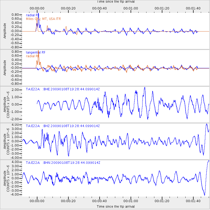
Signal To Noise
| Channel | StoN | STA | LTA |
| TA:E22A: :BHZ:20090108T19:28:44.099014Z | 4.185216 | 1.3113089E-6 | 3.1331928E-7 |
| TA:E22A: :BHN:20090108T19:28:44.099014Z | 1.0727916 | 9.0098644E-7 | 8.398522E-7 |
| TA:E22A: :BHE:20090108T19:28:44.099014Z | 1.8608309 | 7.644867E-7 | 4.1083084E-7 |
| Arrivals |
| Ps | 7.1 SECOND |
| PpPs | 22 SECOND |
| PsPs/PpSs | 29 SECOND |


