You are here: Home > Network List > TA - USArray Transportable Network (new EarthScope stations) Stations List
> Station E22A Miles City, MT, USA > Earthquake Result Viewer
E22A Miles City, MT, USA - Earthquake Result Viewer

| Earthquake location: |
Kuril Islands |
| Earthquake latitude/longitude: |
46.0/151.4 |
| Earthquake time(UTC): |
2009/04/18 (108) 19:17:58 GMT |
| Earthquake Depth: |
35 km |
| Earthquake Magnitude: |
6.3 MB, 6.3 MS, 6.6 MW, 6.4 MW |
| Earthquake Catalog/Contributor: |
WHDF/NEIC |
|
| Network: |
TA USArray Transportable Network (new EarthScope stations) |
| Station: |
E22A Miles City, MT, USA |
| Lat/Lon: |
46.44 N/105.95 W |
| Elevation: |
784 m |
|
| Distance: |
65.6 deg |
| Az: |
47.806 deg |
| Baz: |
311.705 deg |
| Ray Param: |
0.058091428 |
| Estimated Moho Depth: |
44.5 km |
| Estimated Crust Vp/Vs: |
1.89 |
| Assumed Crust Vp: |
6.438 km/s |
| Estimated Crust Vs: |
3.411 km/s |
| Estimated Crust Poisson's Ratio: |
0.30 |
|
| Radial Match: |
94.68536 % |
| Radial Bump: |
324 |
| Transverse Match: |
83.74671 % |
| Transverse Bump: |
400 |
| SOD ConfigId: |
2658 |
| Insert Time: |
2010-03-06 19:49:47.883 +0000 |
| GWidth: |
2.5 |
| Max Bumps: |
400 |
| Tol: |
0.001 |
|
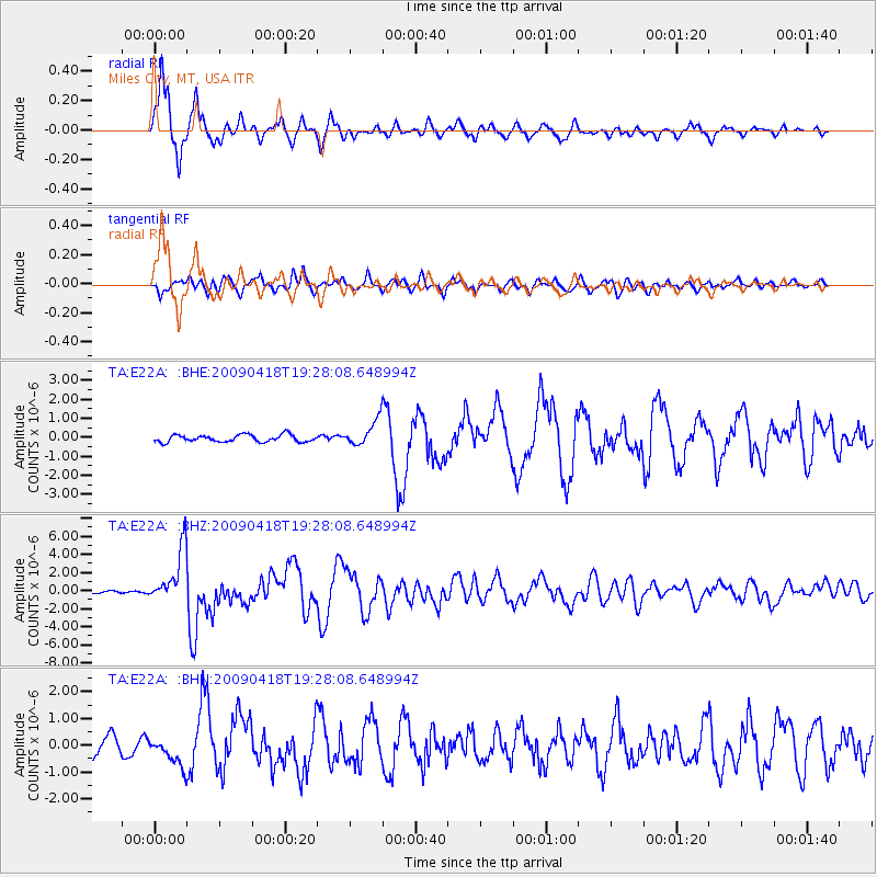
Signal To Noise
| Channel | StoN | STA | LTA |
| TA:E22A: :BHZ:20090418T19:28:08.648994Z | 17.475805 | 2.9702803E-6 | 1.6996529E-7 |
| TA:E22A: :BHN:20090418T19:28:08.648994Z | 1.6850356 | 5.182635E-7 | 3.0756829E-7 |
| TA:E22A: :BHE:20090418T19:28:08.648994Z | 3.5807126 | 6.7643964E-7 | 1.8891203E-7 |
| Arrivals |
| Ps | 6.4 SECOND |
| PpPs | 19 SECOND |
| PsPs/PpSs | 26 SECOND |


