You are here: Home > Network List > TA - USArray Transportable Network (new EarthScope stations) Stations List
> Station E22A Miles City, MT, USA > Earthquake Result Viewer
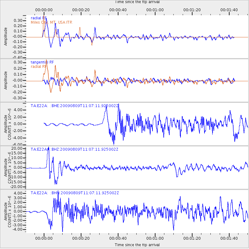
E22A Miles City, MT, USA - Earthquake Result Viewer
*The percent match for this event was below the threshold and hence no stack was calculated.
| Earthquake location: |
Near S. Coast Of Honshu, Japan |
| Earthquake latitude/longitude: |
33.2/137.9 |
| Earthquake time(UTC): |
2009/08/09 (221) 10:55:55 GMT |
| Earthquake Depth: |
297 km |
| Earthquake Magnitude: |
6.5 MB, 7.1 MW, 7.1 MW |
| Earthquake Catalog/Contributor: |
WHDF/NEIC |
|
| Network: |
TA USArray Transportable Network (new EarthScope stations) |
| Station: |
E22A Miles City, MT, USA |
| Lat/Lon: |
46.44 N/105.95 W |
| Elevation: |
784 m |
|
| Distance: |
82.1 deg |
| Az: |
38.828 deg |
| Baz: |
310.497 deg |
| Ray Param: |
$rayparam |
*The percent match for this event was below the threshold and hence was not used in the summary stack. |
|
| Radial Match: |
93.58352 % |
| Radial Bump: |
400 |
| Transverse Match: |
80.21787 % |
| Transverse Bump: |
400 |
| SOD ConfigId: |
2622 |
| Insert Time: |
2010-03-06 19:50:13.426 +0000 |
| GWidth: |
2.5 |
| Max Bumps: |
400 |
| Tol: |
0.001 |
|
Signal To Noise
| Channel | StoN | STA | LTA |
| TA:E22A: :BHZ:20090809T11:07:11.925002Z | 105.32345 | 9.185092E-6 | 8.720842E-8 |
| TA:E22A: :BHN:20090809T11:07:11.925002Z | 12.294811 | 1.6636346E-6 | 1.3531194E-7 |
| TA:E22A: :BHE:20090809T11:07:11.925002Z | 10.636089 | 2.2383654E-6 | 2.1045004E-7 |
| Arrivals |
| Ps | |
| PpPs | |
| PsPs/PpSs | |


