You are here: Home > Network List > TS - TERRAscope (Southern California Seismic Network) Stations List
> Station CALB Calabasas, California, USA > Earthquake Result Viewer
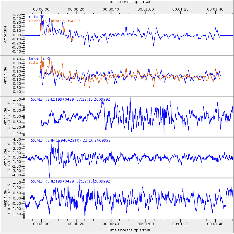
CALB Calabasas, California, USA - Earthquake Result Viewer
*The percent match for this event was below the threshold and hence no stack was calculated.
| Earthquake location: |
Santiago Del Estero Prov., Arg. |
| Earthquake latitude/longitude: |
-28.3/-63.2 |
| Earthquake time(UTC): |
1994/04/29 (119) 07:11:30 GMT |
| Earthquake Depth: |
573 km |
| Earthquake Magnitude: |
6.4 MB, 6.0 UNKNOWN, 6.9 MW |
| Earthquake Catalog/Contributor: |
WHDF/NEIC |
|
| Network: |
TS TERRAscope (Southern California Seismic Network) |
| Station: |
CALB Calabasas, California, USA |
| Lat/Lon: |
34.14 N/118.63 W |
| Elevation: |
0.0 m |
|
| Distance: |
81.3 deg |
| Az: |
316.283 deg |
| Baz: |
132.713 deg |
| Ray Param: |
$rayparam |
*The percent match for this event was below the threshold and hence was not used in the summary stack. |
|
| Radial Match: |
51.35396 % |
| Radial Bump: |
400 |
| Transverse Match: |
79.12901 % |
| Transverse Bump: |
400 |
| SOD ConfigId: |
4480 |
| Insert Time: |
2010-02-26 14:04:50.666 +0000 |
| GWidth: |
2.5 |
| Max Bumps: |
400 |
| Tol: |
0.001 |
|
Signal To Noise
| Channel | StoN | STA | LTA |
| TS:CALB: :BHN:19940429T07:22:16.260999Z | 3.8186402 | 1.1666525E-6 | 3.0551516E-7 |
| TS:CALB: :BHE:19940429T07:22:16.260999Z | 1.4489549 | 5.918796E-7 | 4.0848724E-7 |
| TS:CALB: :BHZ:19940429T07:22:16.260999Z | 1.4509995 | 4.783546E-7 | 3.2967245E-7 |
| Arrivals |
| Ps | |
| PpPs | |
| PsPs/PpSs | |


