You are here: Home > Network List > TA - USArray Transportable Network (new EarthScope stations) Stations List
> Station E22A Miles City, MT, USA > Earthquake Result Viewer
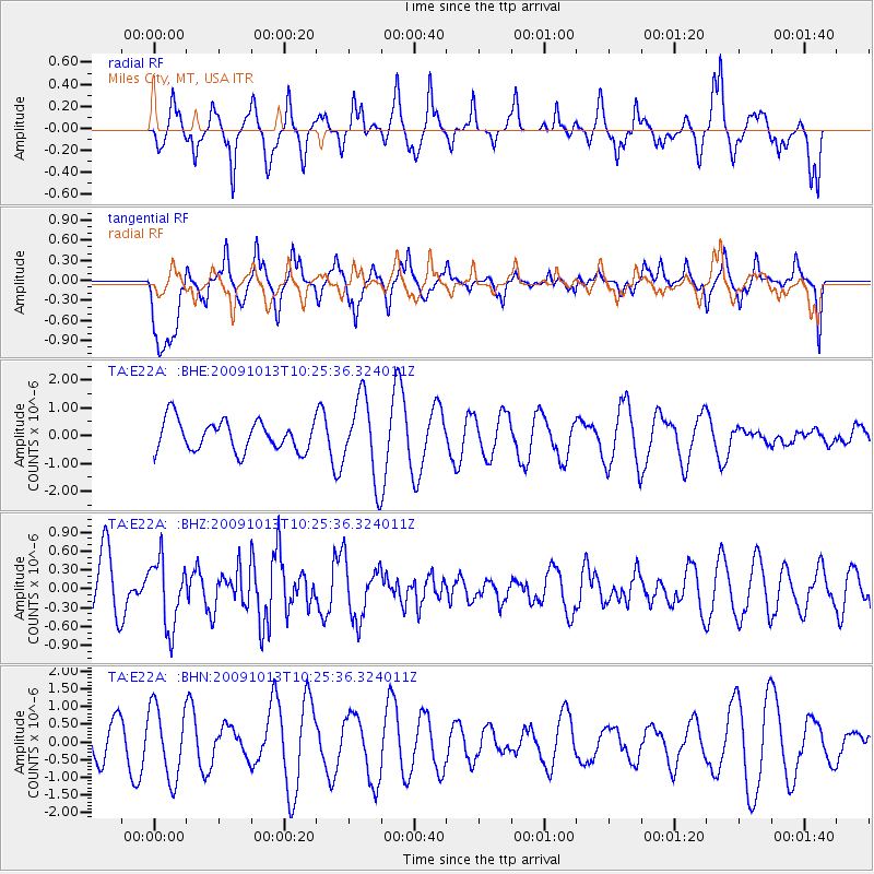
E22A Miles City, MT, USA - Earthquake Result Viewer
*The percent match for this event was below the threshold and hence no stack was calculated.
| Earthquake location: |
Kuril Islands |
| Earthquake latitude/longitude: |
44.6/149.1 |
| Earthquake time(UTC): |
2009/10/13 (286) 10:15:13 GMT |
| Earthquake Depth: |
40 km |
| Earthquake Magnitude: |
5.6 MB, 5.2 MS, 5.7 MW, 5.6 MW |
| Earthquake Catalog/Contributor: |
WHDF/NEIC |
|
| Network: |
TA USArray Transportable Network (new EarthScope stations) |
| Station: |
E22A Miles City, MT, USA |
| Lat/Lon: |
46.44 N/105.95 W |
| Elevation: |
784 m |
|
| Distance: |
67.8 deg |
| Az: |
46.202 deg |
| Baz: |
311.765 deg |
| Ray Param: |
$rayparam |
*The percent match for this event was below the threshold and hence was not used in the summary stack. |
|
| Radial Match: |
62.42935 % |
| Radial Bump: |
367 |
| Transverse Match: |
78.227 % |
| Transverse Bump: |
400 |
| SOD ConfigId: |
2622 |
| Insert Time: |
2010-03-06 19:50:47.735 +0000 |
| GWidth: |
2.5 |
| Max Bumps: |
400 |
| Tol: |
0.001 |
|
Signal To Noise
| Channel | StoN | STA | LTA |
| TA:E22A: :BHZ:20091013T10:25:36.324011Z | 1.3233982 | 5.307623E-7 | 4.0106016E-7 |
| TA:E22A: :BHN:20091013T10:25:36.324011Z | 0.92570436 | 1.0139133E-6 | 1.0952884E-6 |
| TA:E22A: :BHE:20091013T10:25:36.324011Z | 2.6514177 | 1.4430229E-6 | 5.442458E-7 |
| Arrivals |
| Ps | |
| PpPs | |
| PsPs/PpSs | |


