You are here: Home > Network List > TA - USArray Transportable Network (new EarthScope stations) Stations List
> Station E22A Miles City, MT, USA > Earthquake Result Viewer
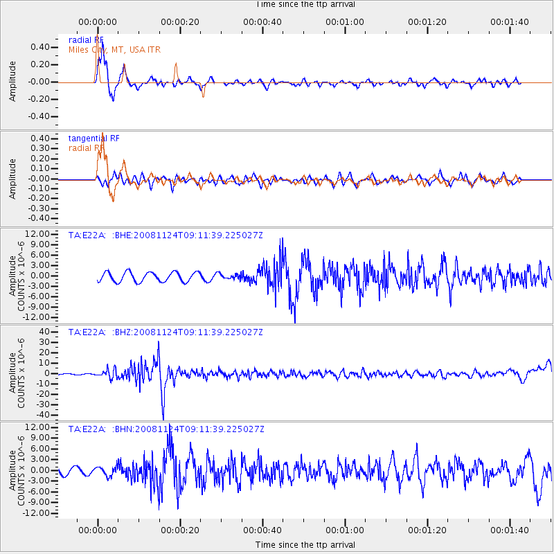
E22A Miles City, MT, USA - Earthquake Result Viewer
*The percent match for this event was below the threshold and hence no stack was calculated.
| Earthquake location: |
Sea Of Okhotsk |
| Earthquake latitude/longitude: |
54.2/154.3 |
| Earthquake time(UTC): |
2008/11/24 (329) 09:02:58 GMT |
| Earthquake Depth: |
492 km |
| Earthquake Magnitude: |
6.5 MB, 7.3 MW, 7.3 MW |
| Earthquake Catalog/Contributor: |
WHDF/NEIC |
|
| Network: |
TA USArray Transportable Network (new EarthScope stations) |
| Station: |
E22A Miles City, MT, USA |
| Lat/Lon: |
46.44 N/105.95 W |
| Elevation: |
784 m |
|
| Distance: |
58.9 deg |
| Az: |
52.717 deg |
| Baz: |
317.474 deg |
| Ray Param: |
$rayparam |
*The percent match for this event was below the threshold and hence was not used in the summary stack. |
|
| Radial Match: |
86.86298 % |
| Radial Bump: |
326 |
| Transverse Match: |
67.35497 % |
| Transverse Bump: |
396 |
| SOD ConfigId: |
2658 |
| Insert Time: |
2010-03-06 19:51:00.006 +0000 |
| GWidth: |
2.5 |
| Max Bumps: |
400 |
| Tol: |
0.001 |
|
Signal To Noise
| Channel | StoN | STA | LTA |
| TA:E22A: :BHZ:20081124T09:11:39.225027Z | 11.175284 | 4.076665E-6 | 3.6479292E-7 |
| TA:E22A: :BHN:20081124T09:11:39.225027Z | 1.4777389 | 1.21602E-6 | 8.228924E-7 |
| TA:E22A: :BHE:20081124T09:11:39.225027Z | 0.5409817 | 7.383026E-7 | 1.3647459E-6 |
| Arrivals |
| Ps | |
| PpPs | |
| PsPs/PpSs | |


