You are here: Home > Network List > G - GEOSCOPE Stations List
> Station MPG Montagne des Peres, French Guyana > Earthquake Result Viewer
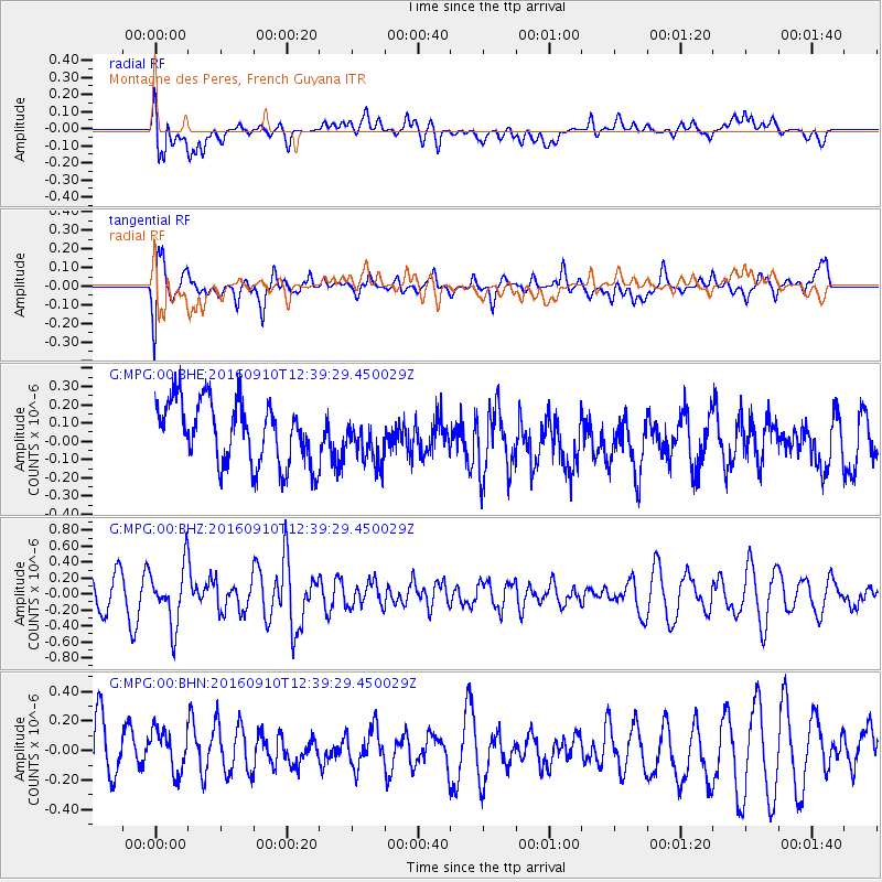
MPG Montagne des Peres, French Guyana - Earthquake Result Viewer
*The percent match for this event was below the threshold and hence no stack was calculated.
| Earthquake location: |
Lake Victoria Region |
| Earthquake latitude/longitude: |
-1.0/31.5 |
| Earthquake time(UTC): |
2016/09/10 (254) 12:27:28 GMT |
| Earthquake Depth: |
10 km |
| Earthquake Magnitude: |
5.9 MWW, 5.8 MWB, 5.9 MWC |
| Earthquake Catalog/Contributor: |
NEIC PDE/NEIC COMCAT |
|
| Network: |
G GEOSCOPE |
| Station: |
MPG Montagne des Peres, French Guyana |
| Lat/Lon: |
5.11 N/52.64 W |
| Elevation: |
147 m |
|
| Distance: |
84.3 deg |
| Az: |
275.205 deg |
| Baz: |
91.544 deg |
| Ray Param: |
$rayparam |
*The percent match for this event was below the threshold and hence was not used in the summary stack. |
|
| Radial Match: |
53.999996 % |
| Radial Bump: |
400 |
| Transverse Match: |
71.61073 % |
| Transverse Bump: |
400 |
| SOD ConfigId: |
1634031 |
| Insert Time: |
2016-09-24 12:28:45.664 +0000 |
| GWidth: |
2.5 |
| Max Bumps: |
400 |
| Tol: |
0.001 |
|
Signal To Noise
| Channel | StoN | STA | LTA |
| G:MPG:00:BHZ:20160910T12:39:29.450029Z | 1.7799432 | 3.6958846E-7 | 2.076406E-7 |
| G:MPG:00:BHN:20160910T12:39:29.450029Z | 0.76835585 | 1.4874865E-7 | 1.9359344E-7 |
| G:MPG:00:BHE:20160910T12:39:29.450029Z | 0.73016584 | 1.2435717E-7 | 1.7031358E-7 |
| Arrivals |
| Ps | |
| PpPs | |
| PsPs/PpSs | |


