You are here: Home > Network List > TA - USArray Transportable Network (new EarthScope stations) Stations List
> Station E22A Miles City, MT, USA > Earthquake Result Viewer
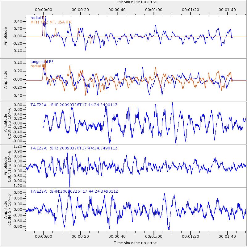
E22A Miles City, MT, USA - Earthquake Result Viewer
*The percent match for this event was below the threshold and hence no stack was calculated.
| Earthquake location: |
Near Coast Of Northern Peru |
| Earthquake latitude/longitude: |
-5.7/-81.3 |
| Earthquake time(UTC): |
2009/03/26 (085) 17:35:14 GMT |
| Earthquake Depth: |
10 km |
| Earthquake Magnitude: |
5.6 MB, 5.5 MS, 5.8 MW, 5.7 MW |
| Earthquake Catalog/Contributor: |
WHDF/NEIC |
|
| Network: |
TA USArray Transportable Network (new EarthScope stations) |
| Station: |
E22A Miles City, MT, USA |
| Lat/Lon: |
46.44 N/105.95 W |
| Elevation: |
784 m |
|
| Distance: |
56.3 deg |
| Az: |
339.759 deg |
| Baz: |
150.144 deg |
| Ray Param: |
$rayparam |
*The percent match for this event was below the threshold and hence was not used in the summary stack. |
|
| Radial Match: |
58.98272 % |
| Radial Bump: |
400 |
| Transverse Match: |
56.646324 % |
| Transverse Bump: |
400 |
| SOD ConfigId: |
2658 |
| Insert Time: |
2010-03-06 19:51:25.271 +0000 |
| GWidth: |
2.5 |
| Max Bumps: |
400 |
| Tol: |
0.001 |
|
Signal To Noise
| Channel | StoN | STA | LTA |
| TA:E22A: :BHZ:20090326T17:44:24.349011Z | 1.6585909 | 3.5939715E-7 | 2.1668825E-7 |
| TA:E22A: :BHN:20090326T17:44:24.349011Z | 0.6376577 | 1.5467724E-7 | 2.4257093E-7 |
| TA:E22A: :BHE:20090326T17:44:24.349011Z | 1.0429715 | 3.0304145E-7 | 2.9055582E-7 |
| Arrivals |
| Ps | |
| PpPs | |
| PsPs/PpSs | |


