You are here: Home > Network List > TA - USArray Transportable Network (new EarthScope stations) Stations List
> Station E22A Miles City, MT, USA > Earthquake Result Viewer
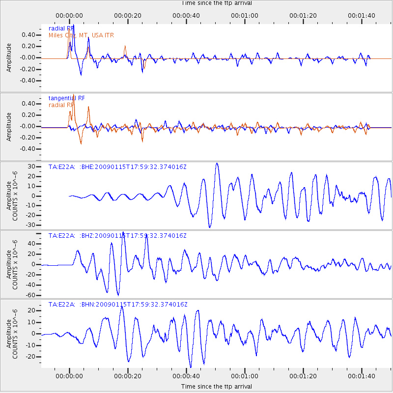
E22A Miles City, MT, USA - Earthquake Result Viewer
*The percent match for this event was below the threshold and hence no stack was calculated.
| Earthquake location: |
East Of Kuril Islands |
| Earthquake latitude/longitude: |
46.9/155.2 |
| Earthquake time(UTC): |
2009/01/15 (015) 17:49:39 GMT |
| Earthquake Depth: |
36 km |
| Earthquake Magnitude: |
6.9 MB, 7.5 MS, 7.4 MW, 7.4 MW |
| Earthquake Catalog/Contributor: |
WHDF/NEIC |
|
| Network: |
TA USArray Transportable Network (new EarthScope stations) |
| Station: |
E22A Miles City, MT, USA |
| Lat/Lon: |
46.44 N/105.95 W |
| Elevation: |
784 m |
|
| Distance: |
63.1 deg |
| Az: |
49.99 deg |
| Baz: |
310.529 deg |
| Ray Param: |
$rayparam |
*The percent match for this event was below the threshold and hence was not used in the summary stack. |
|
| Radial Match: |
97.342384 % |
| Radial Bump: |
284 |
| Transverse Match: |
91.85868 % |
| Transverse Bump: |
400 |
| SOD ConfigId: |
2834 |
| Insert Time: |
2010-03-06 19:51:50.229 +0000 |
| GWidth: |
2.5 |
| Max Bumps: |
400 |
| Tol: |
0.001 |
|
Signal To Noise
| Channel | StoN | STA | LTA |
| TA:E22A: :BHZ:20090115T17:59:32.374016Z | 50.484104 | 1.3478052E-5 | 2.6697614E-7 |
| TA:E22A: :BHN:20090115T17:59:32.374016Z | 3.4393659 | 4.421506E-6 | 1.2855586E-6 |
| TA:E22A: :BHE:20090115T17:59:32.374016Z | 2.7831426 | 5.705054E-6 | 2.0498605E-6 |
| Arrivals |
| Ps | |
| PpPs | |
| PsPs/PpSs | |


