You are here: Home > Network List > TA - USArray Transportable Network (new EarthScope stations) Stations List
> Station E23A Ismay, MT, USA > Earthquake Result Viewer
E23A Ismay, MT, USA - Earthquake Result Viewer
| Earthquake location: |
Kermadec Islands Region |
| Earthquake latitude/longitude: |
-27.4/-176.3 |
| Earthquake time(UTC): |
2009/02/18 (049) 21:53:45 GMT |
| Earthquake Depth: |
25 km |
| Earthquake Magnitude: |
6.8 MB, 7.2 MS, 6.9 MW, 6.9 MW |
| Earthquake Catalog/Contributor: |
WHDF/NEIC |
|
| Network: |
TA USArray Transportable Network (new EarthScope stations) |
| Station: |
E23A Ismay, MT, USA |
| Lat/Lon: |
46.50 N/105.31 W |
| Elevation: |
750 m |
|
| Distance: |
97.6 deg |
| Az: |
41.223 deg |
| Baz: |
237.989 deg |
| Ray Param: |
0.04016703 |
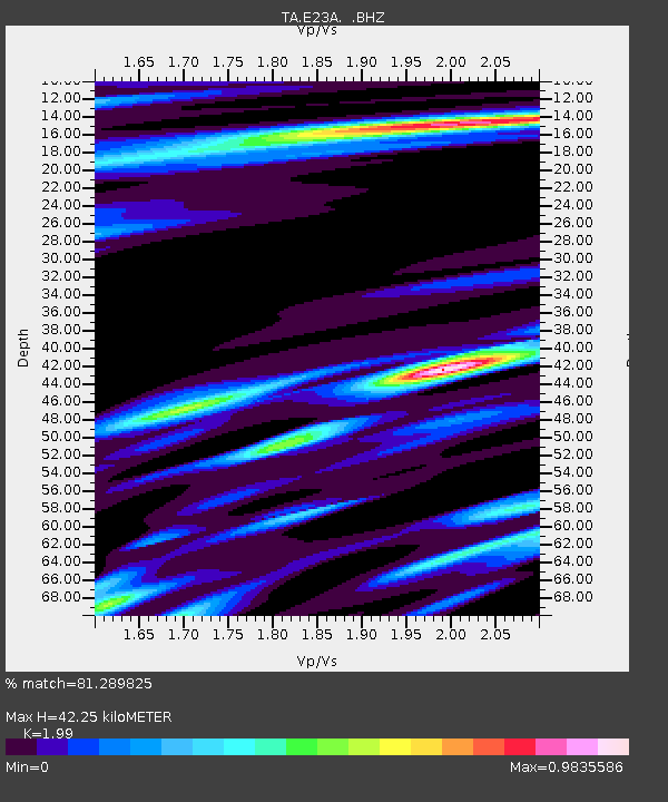
| Estimated Moho Depth: |
42.25 km |
| Estimated Crust Vp/Vs: |
1.99 |
| Assumed Crust Vp: |
6.438 km/s |
| Estimated Crust Vs: |
3.235 km/s |
| Estimated Crust Poisson's Ratio: |
0.33 |
|
| Radial Match: |
81.289825 % |
| Radial Bump: |
264 |
| Transverse Match: |
85.60411 % |
| Transverse Bump: |
357 |
| SOD ConfigId: |
2658 |
| Insert Time: |
2010-03-06 19:52:01.081 +0000 |
| GWidth: |
2.5 |
| Max Bumps: |
400 |
| Tol: |
0.001 |
|
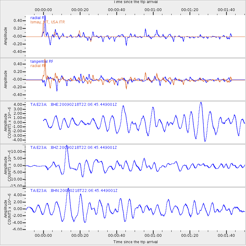
Signal To Noise
| Channel | StoN | STA | LTA |
| TA:E23A: :BHZ:20090218T22:06:45.449001Z | 3.181966 | 1.0393173E-6 | 3.266274E-7 |
| TA:E23A: :BHN:20090218T22:06:45.449001Z | 1.4174331 | 1.221238E-6 | 8.615842E-7 |
| TA:E23A: :BHE:20090218T22:06:45.449001Z | 1.5013722 | 1.1037946E-6 | 7.3519055E-7 |
| Arrivals |
| Ps | 6.6 SECOND |
| PpPs | 19 SECOND |
| PsPs/PpSs | 26 SECOND |


