You are here: Home > Network List > CI - Caltech Regional Seismic Network Stations List
> Station MPM Manuel Prospect Mine, California, USA > Earthquake Result Viewer
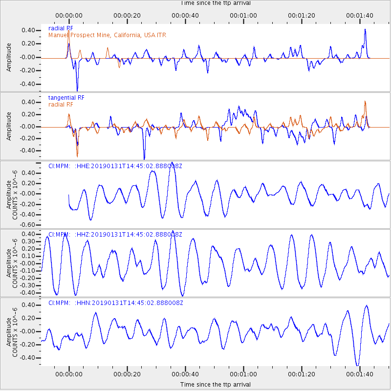
MPM Manuel Prospect Mine, California, USA - Earthquake Result Viewer
*The percent match for this event was below the threshold and hence no stack was calculated.
| Earthquake location: |
South Of Fiji Islands |
| Earthquake latitude/longitude: |
-24.3/-179.8 |
| Earthquake time(UTC): |
2019/01/31 (031) 14:33:57 GMT |
| Earthquake Depth: |
508 km |
| Earthquake Magnitude: |
5.5 Mww |
| Earthquake Catalog/Contributor: |
NEIC PDE/us |
|
| Network: |
CI Caltech Regional Seismic Network |
| Station: |
MPM Manuel Prospect Mine, California, USA |
| Lat/Lon: |
36.06 N/117.49 W |
| Elevation: |
185 m |
|
| Distance: |
84.0 deg |
| Az: |
46.166 deg |
| Baz: |
234.317 deg |
| Ray Param: |
$rayparam |
*The percent match for this event was below the threshold and hence was not used in the summary stack. |
|
| Radial Match: |
66.21806 % |
| Radial Bump: |
400 |
| Transverse Match: |
38.45456 % |
| Transverse Bump: |
400 |
| SOD ConfigId: |
13570011 |
| Insert Time: |
2019-05-02 11:03:44.816 +0000 |
| GWidth: |
2.5 |
| Max Bumps: |
400 |
| Tol: |
0.001 |
|
Signal To Noise
| Channel | StoN | STA | LTA |
| CI:MPM: :HHZ:20190131T14:45:02.888008Z | 1.8338635 | 2.7810873E-7 | 1.5165182E-7 |
| CI:MPM: :HHN:20190131T14:45:02.888008Z | 0.8499512 | 1.9118845E-7 | 2.249405E-7 |
| CI:MPM: :HHE:20190131T14:45:02.888008Z | 1.9670142 | 3.419249E-7 | 1.7382939E-7 |
| Arrivals |
| Ps | |
| PpPs | |
| PsPs/PpSs | |


