You are here: Home > Network List > TA - USArray Transportable Network (new EarthScope stations) Stations List
> Station E23A Ismay, MT, USA > Earthquake Result Viewer
E23A Ismay, MT, USA - Earthquake Result Viewer
| Earthquake location: |
Tonga Islands Region |
| Earthquake latitude/longitude: |
-23.0/-174.7 |
| Earthquake time(UTC): |
2009/03/19 (078) 18:17:40 GMT |
| Earthquake Depth: |
34 km |
| Earthquake Magnitude: |
7.0 MB, 7.6 MS, 7.6 MW, 7.6 MW |
| Earthquake Catalog/Contributor: |
WHDF/NEIC |
|
| Network: |
TA USArray Transportable Network (new EarthScope stations) |
| Station: |
E23A Ismay, MT, USA |
| Lat/Lon: |
46.50 N/105.31 W |
| Elevation: |
750 m |
|
| Distance: |
93.3 deg |
| Az: |
40.353 deg |
| Baz: |
239.698 deg |
| Ray Param: |
0.04128231 |
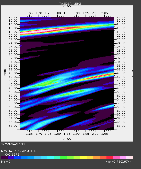
| Estimated Moho Depth: |
17.75 km |
| Estimated Crust Vp/Vs: |
1.67 |
| Assumed Crust Vp: |
6.438 km/s |
| Estimated Crust Vs: |
3.861 km/s |
| Estimated Crust Poisson's Ratio: |
0.22 |
|
| Radial Match: |
97.99603 % |
| Radial Bump: |
388 |
| Transverse Match: |
90.24947 % |
| Transverse Bump: |
400 |
| SOD ConfigId: |
2658 |
| Insert Time: |
2010-03-06 19:52:13.192 +0000 |
| GWidth: |
2.5 |
| Max Bumps: |
400 |
| Tol: |
0.001 |
|
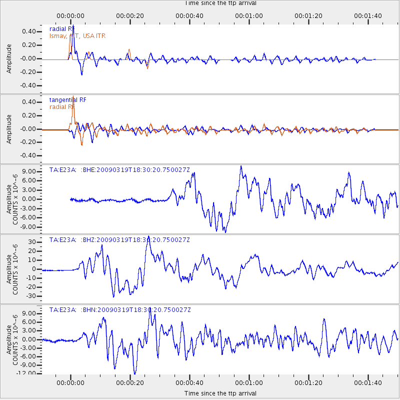
Signal To Noise
| Channel | StoN | STA | LTA |
| TA:E23A: :BHZ:20090319T18:30:20.750027Z | 17.755255 | 4.2712663E-6 | 2.405635E-7 |
| TA:E23A: :BHN:20090319T18:30:20.750027Z | 4.4040647 | 1.1243424E-6 | 2.552965E-7 |
| TA:E23A: :BHE:20090319T18:30:20.750027Z | 4.574165 | 1.4104563E-6 | 3.0835272E-7 |
| Arrivals |
| Ps | 1.9 SECOND |
| PpPs | 7.2 SECOND |
| PsPs/PpSs | 9.1 SECOND |


