You are here: Home > Network List > TS - TERRAscope (Southern California Seismic Network) Stations List
> Station CALB Calabasas, California, USA > Earthquake Result Viewer
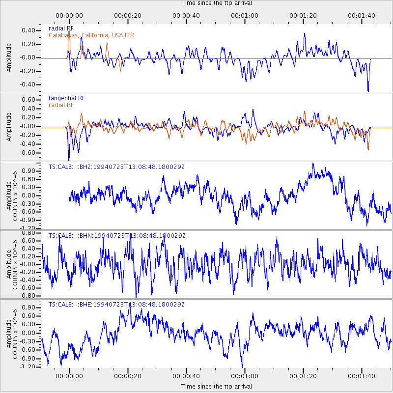
CALB Calabasas, California, USA - Earthquake Result Viewer
*The percent match for this event was below the threshold and hence no stack was calculated.
| Earthquake location: |
Tonga Islands |
| Earthquake latitude/longitude: |
-15.7/-173.1 |
| Earthquake time(UTC): |
1994/07/23 (204) 12:58:00 GMT |
| Earthquake Depth: |
33 km |
| Earthquake Magnitude: |
5.6 MS, 5.3 MB |
| Earthquake Catalog/Contributor: |
WHDF/NEIC |
|
| Network: |
TS TERRAscope (Southern California Seismic Network) |
| Station: |
CALB Calabasas, California, USA |
| Lat/Lon: |
34.14 N/118.63 W |
| Elevation: |
0.0 m |
|
| Distance: |
71.7 deg |
| Az: |
45.302 deg |
| Baz: |
235.627 deg |
| Ray Param: |
$rayparam |
*The percent match for this event was below the threshold and hence was not used in the summary stack. |
|
| Radial Match: |
66.39533 % |
| Radial Bump: |
400 |
| Transverse Match: |
52.630924 % |
| Transverse Bump: |
382 |
| SOD ConfigId: |
4480 |
| Insert Time: |
2010-02-26 14:04:56.551 +0000 |
| GWidth: |
2.5 |
| Max Bumps: |
400 |
| Tol: |
0.001 |
|
Signal To Noise
| Channel | StoN | STA | LTA |
| TS:CALB: :BHN:19940723T13:08:48.180029Z | 0.90101886 | 2.6357282E-7 | 2.9252755E-7 |
| TS:CALB: :BHE:19940723T13:08:48.180029Z | 1.2619255 | 9.283601E-7 | 7.356696E-7 |
| TS:CALB: :BHZ:19940723T13:08:48.180029Z | 1.5104101 | 3.183366E-7 | 2.107617E-7 |
| Arrivals |
| Ps | |
| PpPs | |
| PsPs/PpSs | |


