You are here: Home > Network List > TA - USArray Transportable Network (new EarthScope stations) Stations List
> Station E23A Ismay, MT, USA > Earthquake Result Viewer
E23A Ismay, MT, USA - Earthquake Result Viewer
| Earthquake location: |
Kuril Islands |
| Earthquake latitude/longitude: |
46.0/151.4 |
| Earthquake time(UTC): |
2009/04/18 (108) 19:17:58 GMT |
| Earthquake Depth: |
35 km |
| Earthquake Magnitude: |
6.3 MB, 6.3 MS, 6.6 MW, 6.4 MW |
| Earthquake Catalog/Contributor: |
WHDF/NEIC |
|
| Network: |
TA USArray Transportable Network (new EarthScope stations) |
| Station: |
E23A Ismay, MT, USA |
| Lat/Lon: |
46.50 N/105.31 W |
| Elevation: |
750 m |
|
| Distance: |
65.9 deg |
| Az: |
47.433 deg |
| Baz: |
312.016 deg |
| Ray Param: |
0.057900507 |
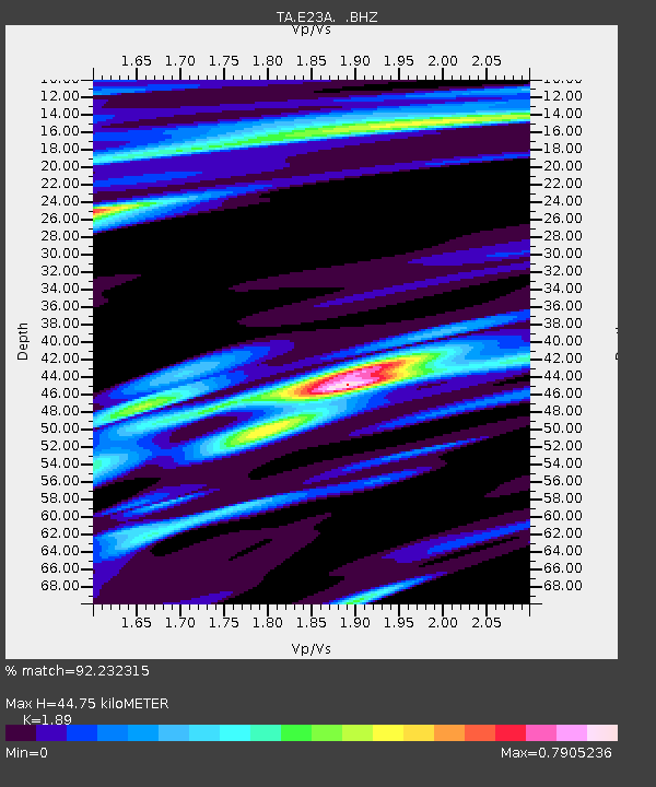
| Estimated Moho Depth: |
44.75 km |
| Estimated Crust Vp/Vs: |
1.89 |
| Assumed Crust Vp: |
6.438 km/s |
| Estimated Crust Vs: |
3.406 km/s |
| Estimated Crust Poisson's Ratio: |
0.31 |
|
| Radial Match: |
92.232315 % |
| Radial Bump: |
321 |
| Transverse Match: |
77.71014 % |
| Transverse Bump: |
400 |
| SOD ConfigId: |
2760 |
| Insert Time: |
2010-03-06 19:52:27.801 +0000 |
| GWidth: |
2.5 |
| Max Bumps: |
400 |
| Tol: |
0.001 |
|
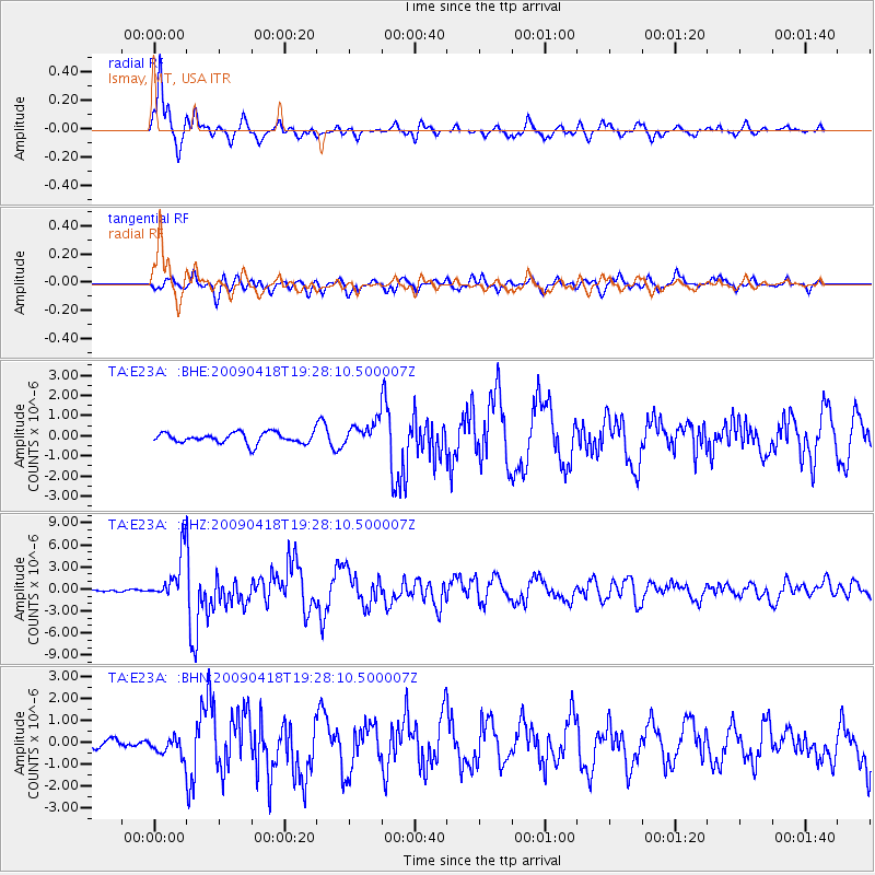
Signal To Noise
| Channel | StoN | STA | LTA |
| TA:E23A: :BHZ:20090418T19:28:10.500007Z | 34.383167 | 3.1139948E-6 | 9.056742E-8 |
| TA:E23A: :BHN:20090418T19:28:10.500007Z | 0.9467761 | 4.0749737E-7 | 4.3040524E-7 |
| TA:E23A: :BHE:20090418T19:28:10.500007Z | 2.241807 | 5.955596E-7 | 2.6566053E-7 |
| Arrivals |
| Ps | 6.4 SECOND |
| PpPs | 19 SECOND |
| PsPs/PpSs | 26 SECOND |


