You are here: Home > Network List > TA - USArray Transportable Network (new EarthScope stations) Stations List
> Station D23K Nanushuk River, AK USA > Earthquake Result Viewer
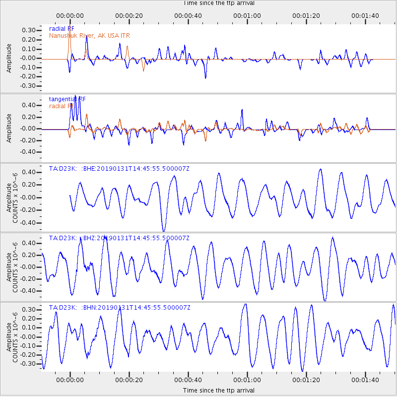
D23K Nanushuk River, AK USA - Earthquake Result Viewer
*The percent match for this event was below the threshold and hence no stack was calculated.
| Earthquake location: |
South Of Fiji Islands |
| Earthquake latitude/longitude: |
-24.3/-179.8 |
| Earthquake time(UTC): |
2019/01/31 (031) 14:33:57 GMT |
| Earthquake Depth: |
508 km |
| Earthquake Magnitude: |
5.5 Mww |
| Earthquake Catalog/Contributor: |
NEIC PDE/us |
|
| Network: |
TA USArray Transportable Network (new EarthScope stations) |
| Station: |
D23K Nanushuk River, AK USA |
| Lat/Lon: |
68.97 N/150.68 W |
| Elevation: |
406 m |
|
| Distance: |
95.4 deg |
| Az: |
10.162 deg |
| Baz: |
206.479 deg |
| Ray Param: |
$rayparam |
*The percent match for this event was below the threshold and hence was not used in the summary stack. |
|
| Radial Match: |
33.93144 % |
| Radial Bump: |
400 |
| Transverse Match: |
66.98517 % |
| Transverse Bump: |
400 |
| SOD ConfigId: |
13570011 |
| Insert Time: |
2019-05-02 11:06:05.724 +0000 |
| GWidth: |
2.5 |
| Max Bumps: |
400 |
| Tol: |
0.001 |
|
Signal To Noise
| Channel | StoN | STA | LTA |
| TA:D23K: :BHZ:20190131T14:45:55.500007Z | 2.4222302 | 3.1488062E-7 | 1.2999615E-7 |
| TA:D23K: :BHN:20190131T14:45:55.500007Z | 0.68749845 | 9.0933206E-8 | 1.3226678E-7 |
| TA:D23K: :BHE:20190131T14:45:55.500007Z | 2.310174 | 2.999521E-7 | 1.298396E-7 |
| Arrivals |
| Ps | |
| PpPs | |
| PsPs/PpSs | |


