You are here: Home > Network List > TA - USArray Transportable Network (new EarthScope stations) Stations List
> Station E23A Ismay, MT, USA > Earthquake Result Viewer
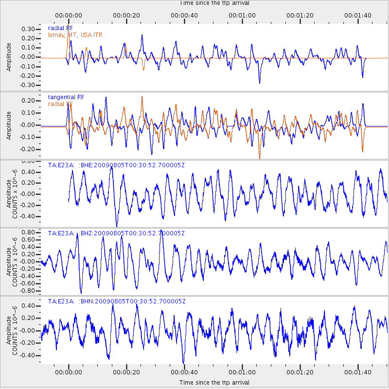
E23A Ismay, MT, USA - Earthquake Result Viewer
*The percent match for this event was below the threshold and hence no stack was calculated.
| Earthquake location: |
Southwestern Ryukyu Isl., Japan |
| Earthquake latitude/longitude: |
24.2/125.1 |
| Earthquake time(UTC): |
2009/08/05 (217) 00:17:58 GMT |
| Earthquake Depth: |
25 km |
| Earthquake Magnitude: |
5.9 MB, 5.9 MS, 6.2 MW, 6.1 MW |
| Earthquake Catalog/Contributor: |
WHDF/NEIC |
|
| Network: |
TA USArray Transportable Network (new EarthScope stations) |
| Station: |
E23A Ismay, MT, USA |
| Lat/Lon: |
46.50 N/105.31 W |
| Elevation: |
750 m |
|
| Distance: |
96.1 deg |
| Az: |
32.368 deg |
| Baz: |
314.97 deg |
| Ray Param: |
$rayparam |
*The percent match for this event was below the threshold and hence was not used in the summary stack. |
|
| Radial Match: |
55.78425 % |
| Radial Bump: |
400 |
| Transverse Match: |
76.26335 % |
| Transverse Bump: |
400 |
| SOD ConfigId: |
2622 |
| Insert Time: |
2010-03-06 19:52:35.828 +0000 |
| GWidth: |
2.5 |
| Max Bumps: |
400 |
| Tol: |
0.001 |
|
Signal To Noise
| Channel | StoN | STA | LTA |
| TA:E23A: :BHZ:20090805T00:30:52.700005Z | 4.3820777 | 4.3109262E-7 | 9.8376304E-8 |
| TA:E23A: :BHN:20090805T00:30:52.700005Z | 1.0821261 | 1.4006955E-7 | 1.294392E-7 |
| TA:E23A: :BHE:20090805T00:30:52.700005Z | 0.99049073 | 2.2359913E-7 | 2.2574581E-7 |
| Arrivals |
| Ps | |
| PpPs | |
| PsPs/PpSs | |


