You are here: Home > Network List > AK - Alaska Regional Network Stations List
> Station PWL Port Wells, AK, USA > Earthquake Result Viewer
PWL Port Wells, AK, USA - Earthquake Result Viewer
| Earthquake location: |
Near Coast Of Chiapas, Mexico |
| Earthquake latitude/longitude: |
14.8/-92.3 |
| Earthquake time(UTC): |
2019/02/01 (032) 16:14:13 GMT |
| Earthquake Depth: |
68 km |
| Earthquake Magnitude: |
6.6 Mww |
| Earthquake Catalog/Contributor: |
NEIC PDE/us |
|
| Network: |
AK Alaska Regional Network |
| Station: |
PWL Port Wells, AK, USA |
| Lat/Lon: |
60.86 N/148.33 W |
| Elevation: |
555 m |
|
| Distance: |
61.0 deg |
| Az: |
332.335 deg |
| Baz: |
113.411 deg |
| Ray Param: |
0.061011154 |
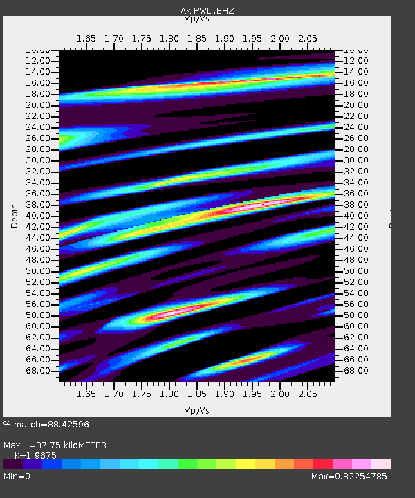
| Estimated Moho Depth: |
37.75 km |
| Estimated Crust Vp/Vs: |
1.97 |
| Assumed Crust Vp: |
6.566 km/s |
| Estimated Crust Vs: |
3.337 km/s |
| Estimated Crust Poisson's Ratio: |
0.33 |
|
| Radial Match: |
88.42596 % |
| Radial Bump: |
400 |
| Transverse Match: |
80.59004 % |
| Transverse Bump: |
400 |
| SOD ConfigId: |
13570011 |
| Insert Time: |
2019-05-02 11:09:05.898 +0000 |
| GWidth: |
2.5 |
| Max Bumps: |
400 |
| Tol: |
0.001 |
|

Signal To Noise
| Channel | StoN | STA | LTA |
| AK:PWL: :BHZ:20190201T16:23:48.48801Z | 13.436437 | 3.568592E-6 | 2.6559067E-7 |
| AK:PWL: :BHN:20190201T16:23:48.48801Z | 3.958793 | 1.1540237E-6 | 2.91509E-7 |
| AK:PWL: :BHE:20190201T16:23:48.48801Z | 5.5835094 | 1.7128745E-6 | 3.067738E-7 |
| Arrivals |
| Ps | 5.8 SECOND |
| PpPs | 16 SECOND |
| PsPs/PpSs | 22 SECOND |


