You are here: Home > Network List > TA - USArray Transportable Network (new EarthScope stations) Stations List
> Station E23A Ismay, MT, USA > Earthquake Result Viewer
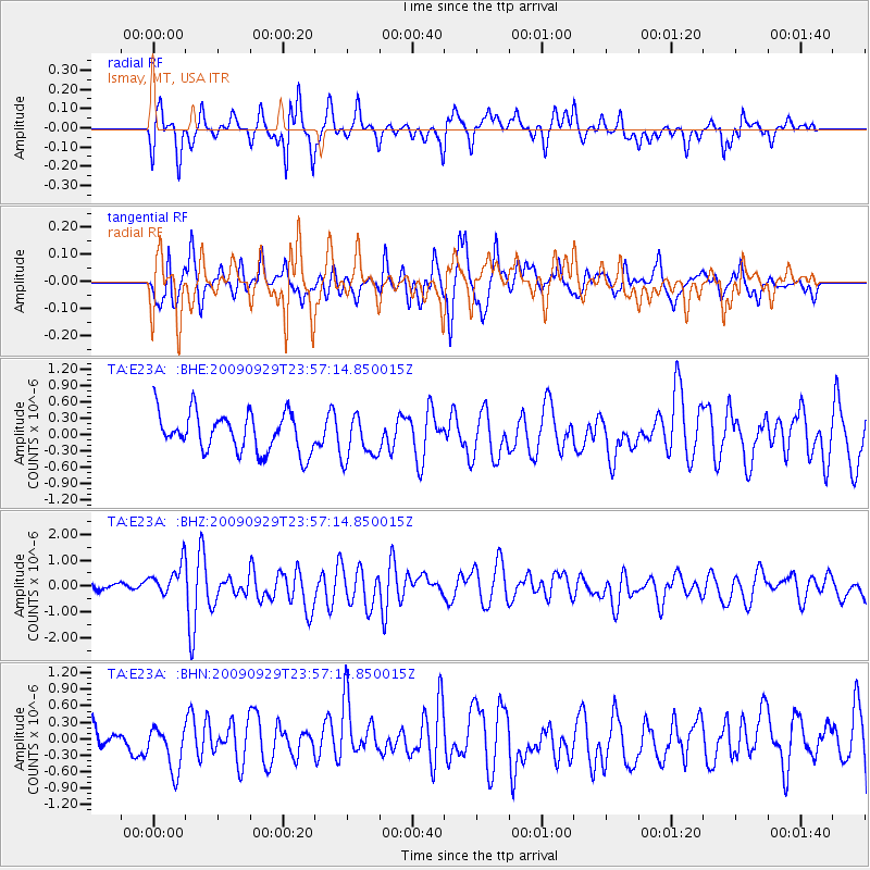
E23A Ismay, MT, USA - Earthquake Result Viewer
*The percent match for this event was below the threshold and hence no stack was calculated.
| Earthquake location: |
Samoa Islands Region |
| Earthquake latitude/longitude: |
-15.8/-172.6 |
| Earthquake time(UTC): |
2009/09/29 (272) 23:45:03 GMT |
| Earthquake Depth: |
10 km |
| Earthquake Magnitude: |
6.0 MB, 5.8 MS |
| Earthquake Catalog/Contributor: |
WHDF/NEIC |
|
| Network: |
TA USArray Transportable Network (new EarthScope stations) |
| Station: |
E23A Ismay, MT, USA |
| Lat/Lon: |
46.50 N/105.31 W |
| Elevation: |
750 m |
|
| Distance: |
86.5 deg |
| Az: |
39.661 deg |
| Baz: |
242.784 deg |
| Ray Param: |
$rayparam |
*The percent match for this event was below the threshold and hence was not used in the summary stack. |
|
| Radial Match: |
69.20046 % |
| Radial Bump: |
348 |
| Transverse Match: |
63.971455 % |
| Transverse Bump: |
326 |
| SOD ConfigId: |
2622 |
| Insert Time: |
2010-03-06 19:52:47.276 +0000 |
| GWidth: |
2.5 |
| Max Bumps: |
400 |
| Tol: |
0.001 |
|
Signal To Noise
| Channel | StoN | STA | LTA |
| TA:E23A: :BHZ:20090929T23:57:14.850015Z | 2.7505867 | 6.4649794E-7 | 2.3504E-7 |
| TA:E23A: :BHN:20090929T23:57:14.850015Z | 1.7139918 | 4.017626E-7 | 2.3440171E-7 |
| TA:E23A: :BHE:20090929T23:57:14.850015Z | 1.1385992 | 4.0626037E-7 | 3.568072E-7 |
| Arrivals |
| Ps | |
| PpPs | |
| PsPs/PpSs | |


