You are here: Home > Network List > TS - TERRAscope (Southern California Seismic Network) Stations List
> Station CALB Calabasas, California, USA > Earthquake Result Viewer
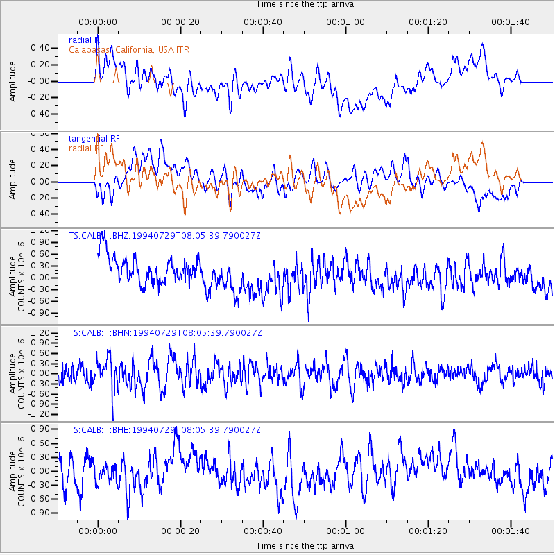
CALB Calabasas, California, USA - Earthquake Result Viewer
*The percent match for this event was below the threshold and hence no stack was calculated.
| Earthquake location: |
Vanuatu Islands |
| Earthquake latitude/longitude: |
-16.8/167.7 |
| Earthquake time(UTC): |
1994/07/29 (210) 07:53:31 GMT |
| Earthquake Depth: |
33 km |
| Earthquake Magnitude: |
5.5 MB, 5.8 MS, 6.2 UNKNOWN, 5.9 MW |
| Earthquake Catalog/Contributor: |
WHDF/NEIC |
|
| Network: |
TS TERRAscope (Southern California Seismic Network) |
| Station: |
CALB Calabasas, California, USA |
| Lat/Lon: |
34.14 N/118.63 W |
| Elevation: |
0.0 m |
|
| Distance: |
86.5 deg |
| Az: |
52.905 deg |
| Baz: |
247.065 deg |
| Ray Param: |
$rayparam |
*The percent match for this event was below the threshold and hence was not used in the summary stack. |
|
| Radial Match: |
46.872368 % |
| Radial Bump: |
400 |
| Transverse Match: |
49.917744 % |
| Transverse Bump: |
400 |
| SOD ConfigId: |
4480 |
| Insert Time: |
2010-02-26 14:04:57.364 +0000 |
| GWidth: |
2.5 |
| Max Bumps: |
400 |
| Tol: |
0.001 |
|
Signal To Noise
| Channel | StoN | STA | LTA |
| TS:CALB: :BHN:19940729T08:05:39.790027Z | 2.7043684 | 5.0053154E-7 | 1.850826E-7 |
| TS:CALB: :BHE:19940729T08:05:39.790027Z | 0.6658782 | 2.8081246E-7 | 4.217175E-7 |
| TS:CALB: :BHZ:19940729T08:05:39.790027Z | 1.5252895 | 5.0033117E-7 | 3.2802373E-7 |
| Arrivals |
| Ps | |
| PpPs | |
| PsPs/PpSs | |


