You are here: Home > Network List > TA - USArray Transportable Network (new EarthScope stations) Stations List
> Station E23A Ismay, MT, USA > Earthquake Result Viewer
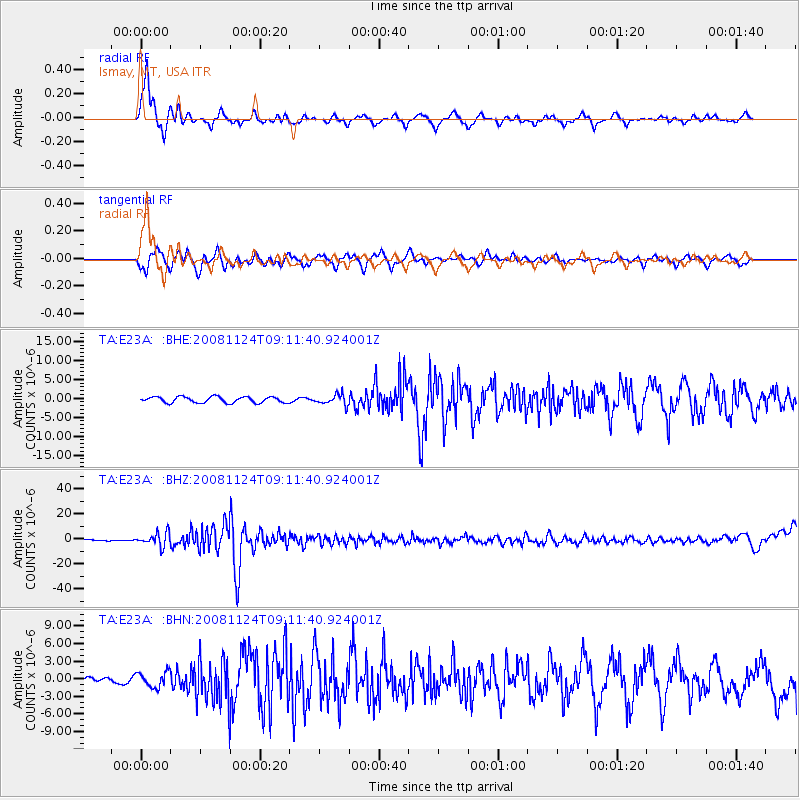
E23A Ismay, MT, USA - Earthquake Result Viewer
*The percent match for this event was below the threshold and hence no stack was calculated.
| Earthquake location: |
Sea Of Okhotsk |
| Earthquake latitude/longitude: |
54.2/154.3 |
| Earthquake time(UTC): |
2008/11/24 (329) 09:02:58 GMT |
| Earthquake Depth: |
492 km |
| Earthquake Magnitude: |
6.5 MB, 7.3 MW, 7.3 MW |
| Earthquake Catalog/Contributor: |
WHDF/NEIC |
|
| Network: |
TA USArray Transportable Network (new EarthScope stations) |
| Station: |
E23A Ismay, MT, USA |
| Lat/Lon: |
46.50 N/105.31 W |
| Elevation: |
750 m |
|
| Distance: |
59.2 deg |
| Az: |
52.288 deg |
| Baz: |
317.718 deg |
| Ray Param: |
$rayparam |
*The percent match for this event was below the threshold and hence was not used in the summary stack. |
|
| Radial Match: |
77.955284 % |
| Radial Bump: |
368 |
| Transverse Match: |
58.61243 % |
| Transverse Bump: |
400 |
| SOD ConfigId: |
2658 |
| Insert Time: |
2010-03-06 19:53:08.691 +0000 |
| GWidth: |
2.5 |
| Max Bumps: |
400 |
| Tol: |
0.001 |
|
Signal To Noise
| Channel | StoN | STA | LTA |
| TA:E23A: :BHZ:20081124T09:11:40.924001Z | 9.688071 | 5.4019833E-6 | 5.575912E-7 |
| TA:E23A: :BHN:20081124T09:11:40.924001Z | 0.6567585 | 1.2910857E-6 | 1.9658455E-6 |
| TA:E23A: :BHE:20081124T09:11:40.924001Z | 1.6936634 | 1.314473E-6 | 7.761123E-7 |
| Arrivals |
| Ps | |
| PpPs | |
| PsPs/PpSs | |


