You are here: Home > Network List > TA - USArray Transportable Network (new EarthScope stations) Stations List
> Station E23A Ismay, MT, USA > Earthquake Result Viewer
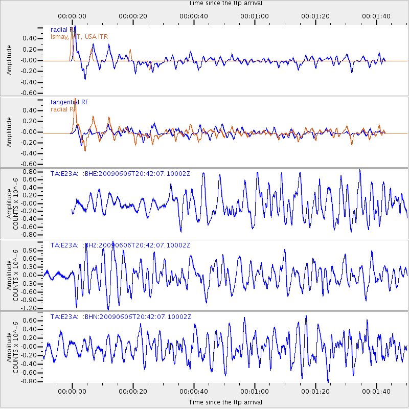
E23A Ismay, MT, USA - Earthquake Result Viewer
*The percent match for this event was below the threshold and hence no stack was calculated.
| Earthquake location: |
Northern Mid-Atlantic Ridge |
| Earthquake latitude/longitude: |
23.9/-46.1 |
| Earthquake time(UTC): |
2009/06/06 (157) 20:33:28 GMT |
| Earthquake Depth: |
14 km |
| Earthquake Magnitude: |
6.0 MB, 5.7 MS, 6.0 MW, 6.0 MW |
| Earthquake Catalog/Contributor: |
WHDF/NEIC |
|
| Network: |
TA USArray Transportable Network (new EarthScope stations) |
| Station: |
E23A Ismay, MT, USA |
| Lat/Lon: |
46.50 N/105.31 W |
| Elevation: |
750 m |
|
| Distance: |
52.1 deg |
| Az: |
311.21 deg |
| Baz: |
94.437 deg |
| Ray Param: |
$rayparam |
*The percent match for this event was below the threshold and hence was not used in the summary stack. |
|
| Radial Match: |
76.281654 % |
| Radial Bump: |
400 |
| Transverse Match: |
65.3916 % |
| Transverse Bump: |
400 |
| SOD ConfigId: |
2648 |
| Insert Time: |
2010-03-06 19:53:11.452 +0000 |
| GWidth: |
2.5 |
| Max Bumps: |
400 |
| Tol: |
0.001 |
|
Signal To Noise
| Channel | StoN | STA | LTA |
| TA:E23A: :BHZ:20090606T20:42:07.10002Z | 5.901632 | 5.407754E-7 | 9.163149E-8 |
| TA:E23A: :BHN:20090606T20:42:07.10002Z | 0.7834282 | 1.3182304E-7 | 1.6826435E-7 |
| TA:E23A: :BHE:20090606T20:42:07.10002Z | 1.2185823 | 1.8474137E-7 | 1.5160353E-7 |
| Arrivals |
| Ps | |
| PpPs | |
| PsPs/PpSs | |


