You are here: Home > Network List > TA - USArray Transportable Network (new EarthScope stations) Stations List
> Station E23A Ismay, MT, USA > Earthquake Result Viewer
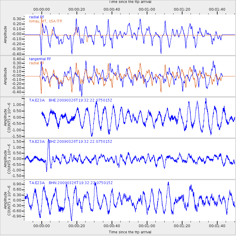
E23A Ismay, MT, USA - Earthquake Result Viewer
*The percent match for this event was below the threshold and hence no stack was calculated.
| Earthquake location: |
Northwest Of Ryukyu Islands |
| Earthquake latitude/longitude: |
27.4/126.7 |
| Earthquake time(UTC): |
2009/03/26 (085) 19:19:59 GMT |
| Earthquake Depth: |
160 km |
| Earthquake Magnitude: |
5.6 MB, 5.9 MW, 5.9 MW |
| Earthquake Catalog/Contributor: |
WHDF/NEIC |
|
| Network: |
TA USArray Transportable Network (new EarthScope stations) |
| Station: |
E23A Ismay, MT, USA |
| Lat/Lon: |
46.50 N/105.31 W |
| Elevation: |
750 m |
|
| Distance: |
92.7 deg |
| Az: |
33.026 deg |
| Baz: |
315.464 deg |
| Ray Param: |
$rayparam |
*The percent match for this event was below the threshold and hence was not used in the summary stack. |
|
| Radial Match: |
48.13733 % |
| Radial Bump: |
400 |
| Transverse Match: |
48.324085 % |
| Transverse Bump: |
374 |
| SOD ConfigId: |
2658 |
| Insert Time: |
2010-03-06 19:53:29.295 +0000 |
| GWidth: |
2.5 |
| Max Bumps: |
400 |
| Tol: |
0.001 |
|
Signal To Noise
| Channel | StoN | STA | LTA |
| TA:E23A: :BHZ:20090326T19:32:22.075015Z | 3.2444932 | 6.675564E-7 | 2.0575058E-7 |
| TA:E23A: :BHN:20090326T19:32:22.075015Z | 2.0208993 | 5.231501E-7 | 2.5886993E-7 |
| TA:E23A: :BHE:20090326T19:32:22.075015Z | 1.9663016 | 7.4312925E-7 | 3.7793248E-7 |
| Arrivals |
| Ps | |
| PpPs | |
| PsPs/PpSs | |


