You are here: Home > Network List > TA - USArray Transportable Network (new EarthScope stations) Stations List
> Station E23A Ismay, MT, USA > Earthquake Result Viewer
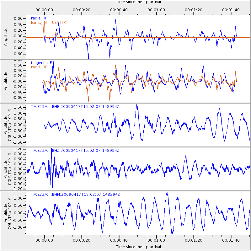
E23A Ismay, MT, USA - Earthquake Result Viewer
*The percent match for this event was below the threshold and hence no stack was calculated.
| Earthquake location: |
Kuril Islands |
| Earthquake latitude/longitude: |
46.2/151.7 |
| Earthquake time(UTC): |
2009/04/17 (107) 14:51:58 GMT |
| Earthquake Depth: |
49 km |
| Earthquake Magnitude: |
5.5 MB, 5.0 MS, 5.7 MW, 5.6 MW |
| Earthquake Catalog/Contributor: |
WHDF/NEIC |
|
| Network: |
TA USArray Transportable Network (new EarthScope stations) |
| Station: |
E23A Ismay, MT, USA |
| Lat/Lon: |
46.50 N/105.31 W |
| Elevation: |
750 m |
|
| Distance: |
65.7 deg |
| Az: |
47.624 deg |
| Baz: |
311.997 deg |
| Ray Param: |
$rayparam |
*The percent match for this event was below the threshold and hence was not used in the summary stack. |
|
| Radial Match: |
67.23254 % |
| Radial Bump: |
374 |
| Transverse Match: |
61.384125 % |
| Transverse Bump: |
373 |
| SOD ConfigId: |
2760 |
| Insert Time: |
2010-03-06 19:53:44.740 +0000 |
| GWidth: |
2.5 |
| Max Bumps: |
400 |
| Tol: |
0.001 |
|
Signal To Noise
| Channel | StoN | STA | LTA |
| TA:E23A: :BHZ:20090417T15:02:07.148994Z | 2.2183888 | 4.6906086E-7 | 2.1144213E-7 |
| TA:E23A: :BHN:20090417T15:02:07.148994Z | 1.0654935 | 3.2818326E-7 | 3.0801058E-7 |
| TA:E23A: :BHE:20090417T15:02:07.148994Z | 1.5603544 | 4.5211698E-7 | 2.8975276E-7 |
| Arrivals |
| Ps | |
| PpPs | |
| PsPs/PpSs | |


