You are here: Home > Network List > TA - USArray Transportable Network (new EarthScope stations) Stations List
> Station E23A Ismay, MT, USA > Earthquake Result Viewer
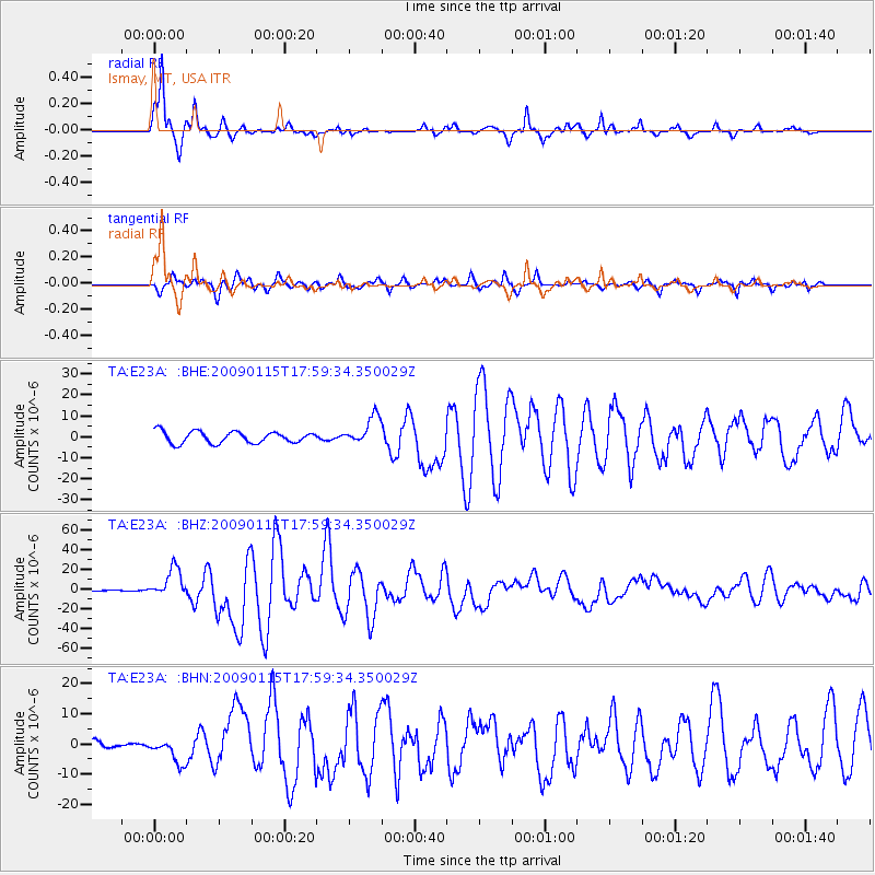
E23A Ismay, MT, USA - Earthquake Result Viewer
*The percent match for this event was below the threshold and hence no stack was calculated.
| Earthquake location: |
East Of Kuril Islands |
| Earthquake latitude/longitude: |
46.9/155.2 |
| Earthquake time(UTC): |
2009/01/15 (015) 17:49:39 GMT |
| Earthquake Depth: |
36 km |
| Earthquake Magnitude: |
6.9 MB, 7.5 MS, 7.4 MW, 7.4 MW |
| Earthquake Catalog/Contributor: |
WHDF/NEIC |
|
| Network: |
TA USArray Transportable Network (new EarthScope stations) |
| Station: |
E23A Ismay, MT, USA |
| Lat/Lon: |
46.50 N/105.31 W |
| Elevation: |
750 m |
|
| Distance: |
63.4 deg |
| Az: |
49.616 deg |
| Baz: |
310.825 deg |
| Ray Param: |
$rayparam |
*The percent match for this event was below the threshold and hence was not used in the summary stack. |
|
| Radial Match: |
97.25021 % |
| Radial Bump: |
310 |
| Transverse Match: |
87.50689 % |
| Transverse Bump: |
400 |
| SOD ConfigId: |
2834 |
| Insert Time: |
2010-03-06 19:53:46.290 +0000 |
| GWidth: |
2.5 |
| Max Bumps: |
400 |
| Tol: |
0.001 |
|
Signal To Noise
| Channel | StoN | STA | LTA |
| TA:E23A: :BHZ:20090115T17:59:34.350029Z | 26.482891 | 1.4899885E-5 | 5.6262303E-7 |
| TA:E23A: :BHN:20090115T17:59:34.350029Z | 2.900957 | 4.2106594E-6 | 1.4514725E-6 |
| TA:E23A: :BHE:20090115T17:59:34.350029Z | 2.4380786 | 6.7368446E-6 | 2.7631777E-6 |
| Arrivals |
| Ps | |
| PpPs | |
| PsPs/PpSs | |


