You are here: Home > Network List > GE - GEOFON Stations List
> Station SUMG GEOFON Station Summit Camp, Greenland > Earthquake Result Viewer
SUMG GEOFON Station Summit Camp, Greenland - Earthquake Result Viewer
| Earthquake location: |
Near Coast Of Chiapas, Mexico |
| Earthquake latitude/longitude: |
14.8/-92.3 |
| Earthquake time(UTC): |
2019/02/01 (032) 16:14:13 GMT |
| Earthquake Depth: |
68 km |
| Earthquake Magnitude: |
6.6 Mww |
| Earthquake Catalog/Contributor: |
NEIC PDE/us |
|
| Network: |
GE GEOFON |
| Station: |
SUMG GEOFON Station Summit Camp, Greenland |
| Lat/Lon: |
72.57 N/38.46 W |
| Elevation: |
3200 m |
|
| Distance: |
65.6 deg |
| Az: |
15.495 deg |
| Baz: |
239.067 deg |
| Ray Param: |
0.058017973 |
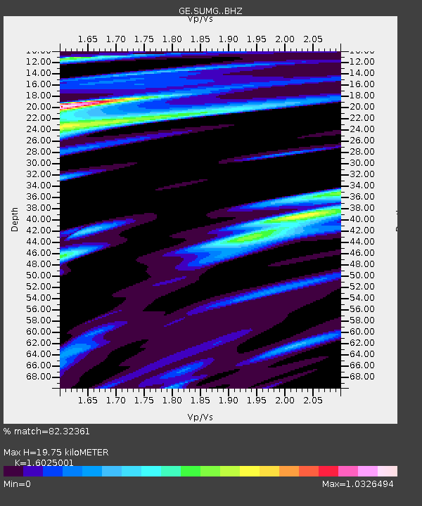
| Estimated Moho Depth: |
19.75 km |
| Estimated Crust Vp/Vs: |
1.60 |
| Assumed Crust Vp: |
6.261 km/s |
| Estimated Crust Vs: |
3.907 km/s |
| Estimated Crust Poisson's Ratio: |
0.18 |
|
| Radial Match: |
82.32361 % |
| Radial Bump: |
399 |
| Transverse Match: |
49.90178 % |
| Transverse Bump: |
379 |
| SOD ConfigId: |
13570011 |
| Insert Time: |
2019-05-02 11:13:37.200 +0000 |
| GWidth: |
2.5 |
| Max Bumps: |
400 |
| Tol: |
0.001 |
|

Signal To Noise
| Channel | StoN | STA | LTA |
| GE:SUMG: :BHZ:20190201T16:24:18.94498Z | 6.818213 | 3.1774225E-6 | 4.6601983E-7 |
| GE:SUMG: :BHN:20190201T16:24:18.94498Z | 1.8499261 | 1.3079267E-6 | 7.0701566E-7 |
| GE:SUMG: :BHE:20190201T16:24:18.94498Z | 4.2838693 | 1.2826999E-6 | 2.9942555E-7 |
| Arrivals |
| Ps | 2.0 SECOND |
| PpPs | 7.9 SECOND |
| PsPs/PpSs | 9.8 SECOND |


