You are here: Home > Network List > TA - USArray Transportable Network (new EarthScope stations) Stations List
> Station R23A Moffat, CO, USA > Earthquake Result Viewer
R23A Moffat, CO, USA - Earthquake Result Viewer
| Earthquake location: |
Tonga Islands |
| Earthquake latitude/longitude: |
-15.4/-173.3 |
| Earthquake time(UTC): |
2009/10/01 (274) 06:13:32 GMT |
| Earthquake Depth: |
10 km |
| Earthquake Magnitude: |
5.6 MB, 5.7 MS, 5.8 MW, 5.7 MW |
| Earthquake Catalog/Contributor: |
WHDF/NEIC |
|
| Network: |
TA USArray Transportable Network (new EarthScope stations) |
| Station: |
R23A Moffat, CO, USA |
| Lat/Lon: |
38.19 N/105.83 W |
| Elevation: |
2547 m |
|
| Distance: |
82.6 deg |
| Az: |
47.203 deg |
| Baz: |
243.93 deg |
| Ray Param: |
0.04680121 |
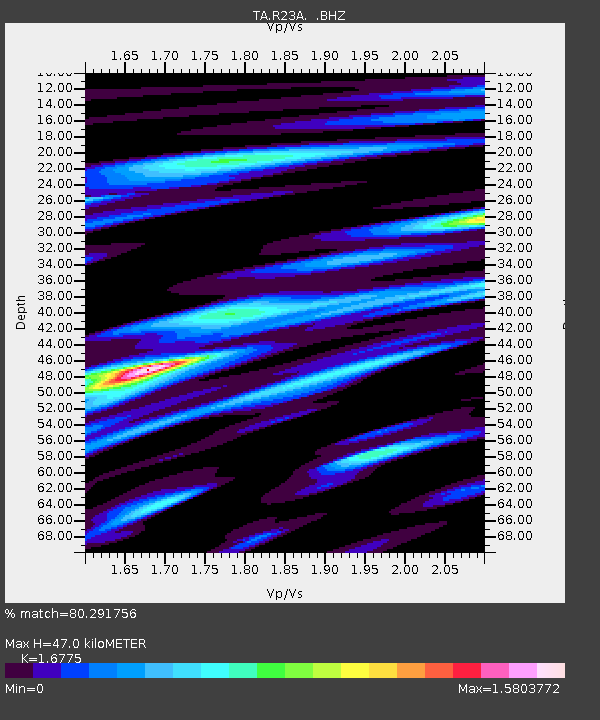
| Estimated Moho Depth: |
47.0 km |
| Estimated Crust Vp/Vs: |
1.68 |
| Assumed Crust Vp: |
6.159 km/s |
| Estimated Crust Vs: |
3.671 km/s |
| Estimated Crust Poisson's Ratio: |
0.22 |
|
| Radial Match: |
80.291756 % |
| Radial Bump: |
400 |
| Transverse Match: |
67.44257 % |
| Transverse Bump: |
400 |
| SOD ConfigId: |
2622 |
| Insert Time: |
2010-03-06 19:54:06.135 +0000 |
| GWidth: |
2.5 |
| Max Bumps: |
400 |
| Tol: |
0.001 |
|
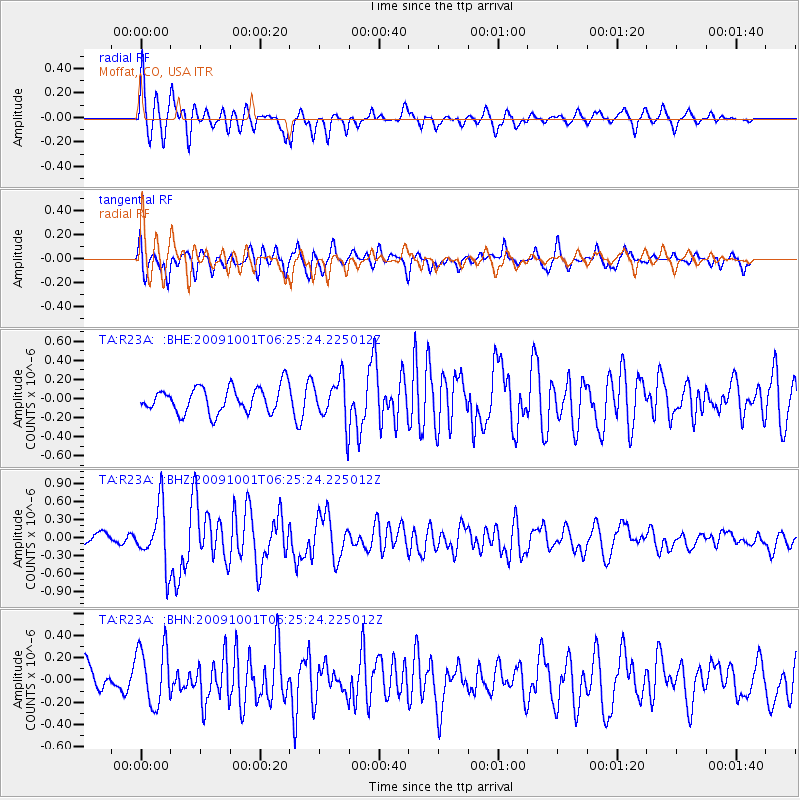
Signal To Noise
| Channel | StoN | STA | LTA |
| TA:R23A: :BHZ:20091001T06:25:24.225012Z | 6.426924 | 4.938502E-7 | 7.6840834E-8 |
| TA:R23A: :BHN:20091001T06:25:24.225012Z | 2.3050323 | 2.6371202E-7 | 1.14407094E-7 |
| TA:R23A: :BHE:20091001T06:25:24.225012Z | 1.7087902 | 2.2792533E-7 | 1.3338403E-7 |
| Arrivals |
| Ps | 5.3 SECOND |
| PpPs | 20 SECOND |
| PsPs/PpSs | 25 SECOND |


