You are here: Home > Network List > N4 - Central and EAstern US Network Stations List
> Station I62A Tamworth, NH, USA > Earthquake Result Viewer
I62A Tamworth, NH, USA - Earthquake Result Viewer
| Earthquake location: |
Near Coast Of Chiapas, Mexico |
| Earthquake latitude/longitude: |
14.8/-92.3 |
| Earthquake time(UTC): |
2019/02/01 (032) 16:14:13 GMT |
| Earthquake Depth: |
68 km |
| Earthquake Magnitude: |
6.6 Mww |
| Earthquake Catalog/Contributor: |
NEIC PDE/us |
|
| Network: |
N4 Central and EAstern US Network |
| Station: |
I62A Tamworth, NH, USA |
| Lat/Lon: |
43.87 N/71.34 W |
| Elevation: |
264 m |
|
| Distance: |
34.1 deg |
| Az: |
27.493 deg |
| Baz: |
218.137 deg |
| Ray Param: |
0.07773366 |
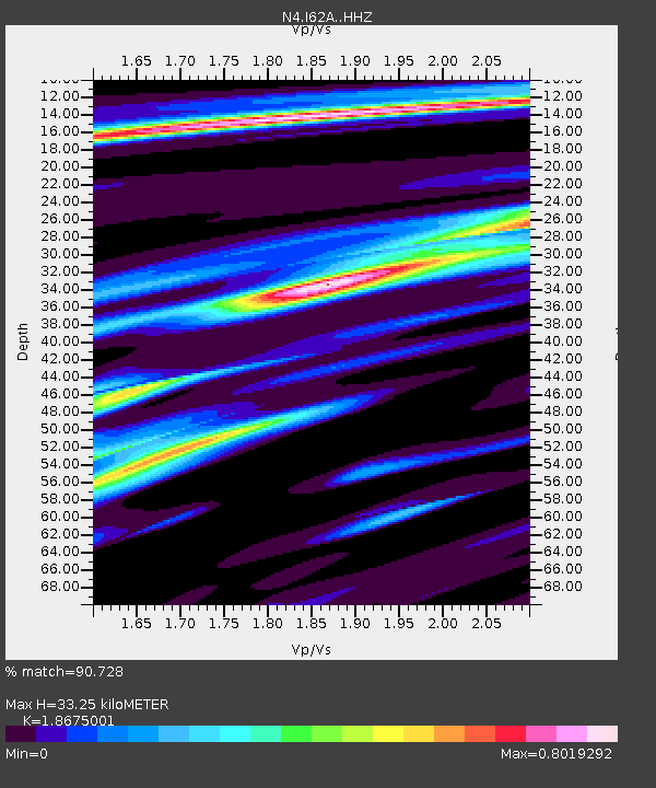
| Estimated Moho Depth: |
33.25 km |
| Estimated Crust Vp/Vs: |
1.87 |
| Assumed Crust Vp: |
6.419 km/s |
| Estimated Crust Vs: |
3.437 km/s |
| Estimated Crust Poisson's Ratio: |
0.30 |
|
| Radial Match: |
90.728 % |
| Radial Bump: |
323 |
| Transverse Match: |
57.946392 % |
| Transverse Bump: |
400 |
| SOD ConfigId: |
13570011 |
| Insert Time: |
2019-05-02 11:14:40.532 +0000 |
| GWidth: |
2.5 |
| Max Bumps: |
400 |
| Tol: |
0.001 |
|

Signal To Noise
| Channel | StoN | STA | LTA |
| N4:I62A: :HHZ:20190201T16:20:20.790012Z | 8.233267 | 3.3448714E-6 | 4.0626298E-7 |
| N4:I62A: :HHN:20190201T16:20:20.790012Z | 3.126455 | 1.3189915E-6 | 4.2188086E-7 |
| N4:I62A: :HHE:20190201T16:20:20.790012Z | 3.9371808 | 1.0897626E-6 | 2.7678755E-7 |
| Arrivals |
| Ps | 4.8 SECOND |
| PpPs | 14 SECOND |
| PsPs/PpSs | 19 SECOND |


