You are here: Home > Network List > N4 - Central and EAstern US Network Stations List
> Station SPMN Marine on St. Croix, MN, USA > Earthquake Result Viewer
SPMN Marine on St. Croix, MN, USA - Earthquake Result Viewer
| Earthquake location: |
Near Coast Of Chiapas, Mexico |
| Earthquake latitude/longitude: |
14.8/-92.3 |
| Earthquake time(UTC): |
2019/02/01 (032) 16:14:13 GMT |
| Earthquake Depth: |
68 km |
| Earthquake Magnitude: |
6.6 Mww |
| Earthquake Catalog/Contributor: |
NEIC PDE/us |
|
| Network: |
N4 Central and EAstern US Network |
| Station: |
SPMN Marine on St. Croix, MN, USA |
| Lat/Lon: |
45.22 N/92.80 W |
| Elevation: |
311 m |
|
| Distance: |
30.4 deg |
| Az: |
359.293 deg |
| Baz: |
179.032 deg |
| Ray Param: |
0.07925115 |
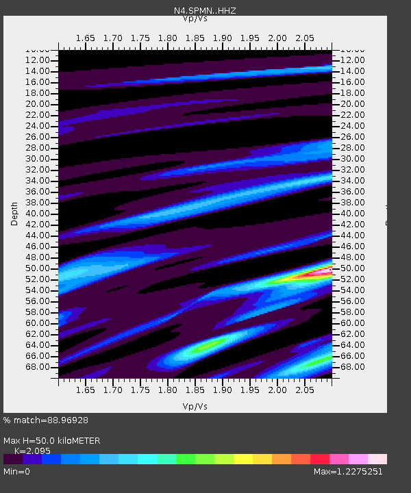
| Estimated Moho Depth: |
50.0 km |
| Estimated Crust Vp/Vs: |
2.10 |
| Assumed Crust Vp: |
6.571 km/s |
| Estimated Crust Vs: |
3.136 km/s |
| Estimated Crust Poisson's Ratio: |
0.35 |
|
| Radial Match: |
88.96928 % |
| Radial Bump: |
230 |
| Transverse Match: |
59.14242 % |
| Transverse Bump: |
400 |
| SOD ConfigId: |
13570011 |
| Insert Time: |
2019-05-02 11:14:50.674 +0000 |
| GWidth: |
2.5 |
| Max Bumps: |
400 |
| Tol: |
0.001 |
|

Signal To Noise
| Channel | StoN | STA | LTA |
| N4:SPMN: :HHZ:20190201T16:19:48.35001Z | 6.6523223 | 1.978349E-6 | 2.9739223E-7 |
| N4:SPMN: :HHN:20190201T16:19:48.35001Z | 5.7766066 | 1.1796145E-6 | 2.0420543E-7 |
| N4:SPMN: :HHE:20190201T16:19:48.35001Z | 1.8164896 | 3.3800177E-7 | 1.8607416E-7 |
| Arrivals |
| Ps | 8.9 SECOND |
| PpPs | 22 SECOND |
| PsPs/PpSs | 31 SECOND |


