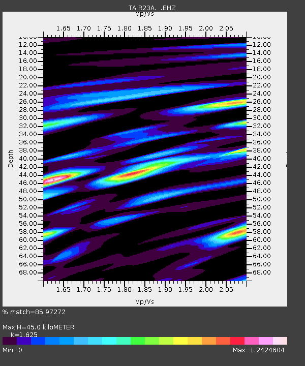
R23A Moffat, CO, USA - Earthquake Result Viewer
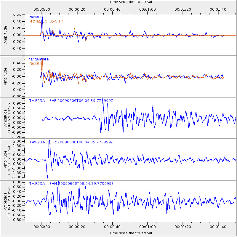
Earthquake location: Near East Coast Of Honshu, Japan
Earthquake latitude/longitude: 35.5/140.9
Earthquake time(UTC): 2009/06/06 (157) 05:52:43 GMT
Earthquake Depth: 34 km
Earthquake Magnitude: 5.8 MB, 5.4 MS, 5.8 MW, 5.7 MW
Earthquake Catalog/Contributor: WHDF/NEIC
Network: TA USArray Transportable Network (new EarthScope stations)
Station: R23A Moffat, CO, USA
Lat/Lon: 38.19 N/105.83 W
Elevation: 2547 m
Distance: 84.2 deg
Az: 46.695 deg
Baz: 311.087 deg
Ray Param: 0.045638338
Estimated Moho Depth: 45.0 km
Estimated Crust Vp/Vs: 1.62
Assumed Crust Vp: 6.159 km/s
Estimated Crust Vs: 3.79 km/s
Estimated Crust Poisson's Ratio: 0.20
Radial Match: 85.97272 %
Radial Bump: 400
Transverse Match: 87.42064 %
Transverse Bump: 400
SOD ConfigId: 2648
Insert Time: 2010-03-06 19:54:17.188 +0000
GWidth: 2.5
Max Bumps: 400
Tol: 0.001

Signal To Noise

ChannelStoNSTALTA
TA:R23A: :BHZ:20090606T06:04:39.773999Z12.1448089.842155E-78.104003E-8
TA:R23A: :BHN:20090606T06:04:39.773999Z6.0895462.6864265E-74.4115378E-8
TA:R23A: :BHE:20090606T06:04:39.773999Z8.0955684.7340532E-75.84771E-8
Arrivals
Ps4.7 SECOND
PpPs19 SECOND
PsPs/PpSs23 SECOND