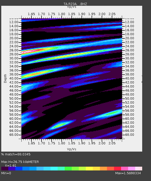
R23A Moffat, CO, USA - Earthquake Result Viewer
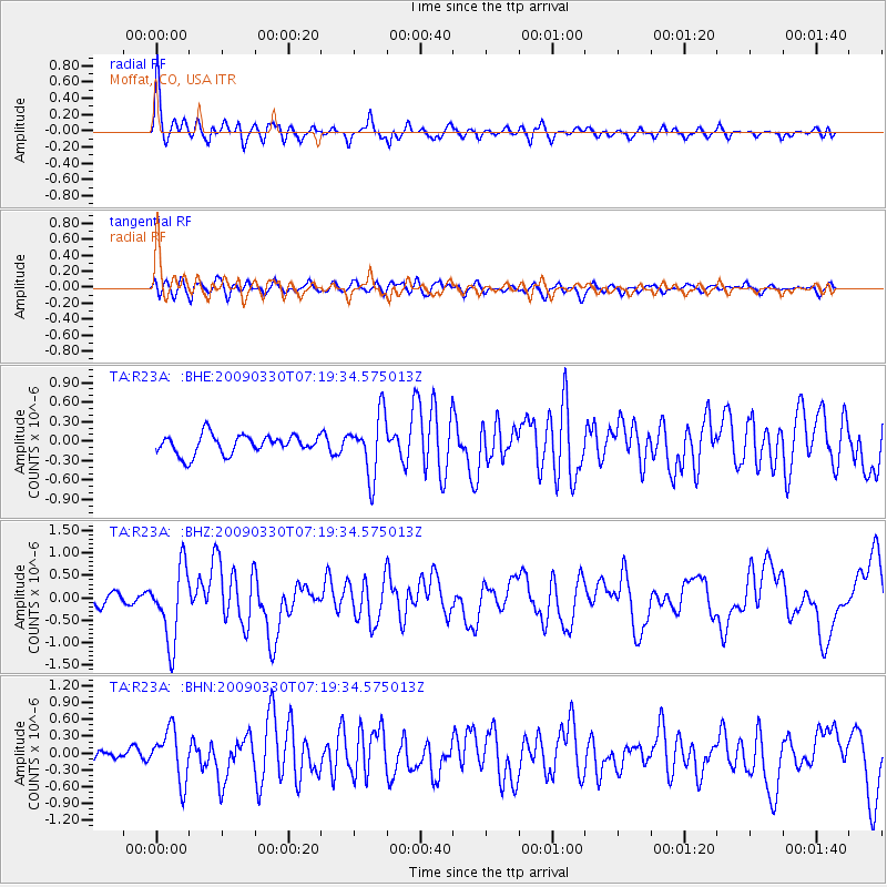
Earthquake location: Kodiak Island Region, Alaska
Earthquake latitude/longitude: 56.5/-152.7
Earthquake time(UTC): 2009/03/30 (089) 07:13:07 GMT
Earthquake Depth: 21 km
Earthquake Magnitude: 5.9 MB, 5.9 MS, 5.9 MW, 5.9 MW
Earthquake Catalog/Contributor: WHDF/NEIC
Network: TA USArray Transportable Network (new EarthScope stations)
Station: R23A Moffat, CO, USA
Lat/Lon: 38.19 N/105.83 W
Elevation: 2547 m
Distance: 35.8 deg
Az: 100.545 deg
Baz: 316.29 deg
Ray Param: 0.07698418
Estimated Moho Depth: 26.75 km
Estimated Crust Vp/Vs: 1.61
Assumed Crust Vp: 6.159 km/s
Estimated Crust Vs: 3.825 km/s
Estimated Crust Poisson's Ratio: 0.19
Radial Match: 88.0345 %
Radial Bump: 400
Transverse Match: 63.934467 %
Transverse Bump: 400
SOD ConfigId: 2658
Insert Time: 2010-03-06 19:54:24.161 +0000
GWidth: 2.5
Max Bumps: 400
Tol: 0.001

Signal To Noise

ChannelStoNSTALTA
TA:R23A: :BHZ:20090330T07:19:34.575013Z7.57607038.2167537E-71.08456675E-7
TA:R23A: :BHN:20090330T07:19:34.575013Z3.84769684.4988397E-71.1692293E-7
TA:R23A: :BHE:20090330T07:19:34.575013Z3.1244.6357673E-71.4839203E-7
Arrivals
Ps2.9 SECOND
PpPs11 SECOND
PsPs/PpSs13 SECOND