You are here: Home > Network List > PO - Portable Observatories for Lithospheric Analysis and Research Investigating Seis Stations List
> Station NMSQ Nemaska Station, QC, CA > Earthquake Result Viewer
NMSQ Nemaska Station, QC, CA - Earthquake Result Viewer
| Earthquake location: |
Near Coast Of Chiapas, Mexico |
| Earthquake latitude/longitude: |
14.8/-92.3 |
| Earthquake time(UTC): |
2019/02/01 (032) 16:14:13 GMT |
| Earthquake Depth: |
68 km |
| Earthquake Magnitude: |
6.6 Mww |
| Earthquake Catalog/Contributor: |
NEIC PDE/us |
|
| Network: |
PO Portable Observatories for Lithospheric Analysis and Research Investigating Seis |
| Station: |
NMSQ Nemaska Station, QC, CA |
| Lat/Lon: |
51.71 N/76.02 W |
| Elevation: |
275 m |
|
| Distance: |
39.1 deg |
| Az: |
16.048 deg |
| Baz: |
205.457 deg |
| Ray Param: |
0.07497642 |
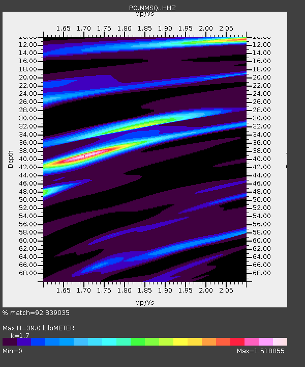
| Estimated Moho Depth: |
39.0 km |
| Estimated Crust Vp/Vs: |
1.70 |
| Assumed Crust Vp: |
6.459 km/s |
| Estimated Crust Vs: |
3.8 km/s |
| Estimated Crust Poisson's Ratio: |
0.24 |
|
| Radial Match: |
92.839035 % |
| Radial Bump: |
227 |
| Transverse Match: |
74.94796 % |
| Transverse Bump: |
400 |
| SOD ConfigId: |
13570011 |
| Insert Time: |
2019-05-02 11:15:40.716 +0000 |
| GWidth: |
2.5 |
| Max Bumps: |
400 |
| Tol: |
0.001 |
|

Signal To Noise
| Channel | StoN | STA | LTA |
| PO:NMSQ: :HHZ:20190201T16:21:03.366001Z | 5.0778446 | 1.8605643E-6 | 3.664083E-7 |
| PO:NMSQ: :HHN:20190201T16:21:03.366001Z | 3.4911778 | 1.0900447E-6 | 3.1222837E-7 |
| PO:NMSQ: :HHE:20190201T16:21:03.366001Z | 0.9901417 | 6.279656E-7 | 6.3421794E-7 |
| Arrivals |
| Ps | 4.6 SECOND |
| PpPs | 15 SECOND |
| PsPs/PpSs | 20 SECOND |


